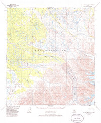
1953 Map of Mount McKinley A-4
USGS Topo · Published 1986About this map
Foraker Glacier and Herron Glacier dominate the southeastern reach of this terrain, where massive ice fields transition into a complex network of glacial meltwater streams. The landscape is defined by the outflow of the Foraker River and Herron River, which snake through the protected expanse of Denali National Park (Wilderness). This mid-century survey captures a remote subarctic environment before modern climatic shifts, documenting the precise extent of the ice and the drainage patterns of tributaries like Highpower Creek and White Creek. The mapping of features such as Somber Creek and Barren Creek underscores the isolation and nomenclature of this interior Alaskan region, serving as a baseline for the wilderness as it was understood in the early 1950s.
Find a feature on this map
9 named features on this map. Tap any name to fly to it.
Don’t see what you’re looking for? This feature index may not catch every label — zoom into the map to look around manually.
Map Details
Editions of this 1953 Mount McKinley A-4 Map
2 editions found
Other maps of this area

1950 · Talkeetna
USGS Topo · 1:250,000

1951 · Talkeetna
USGS Topo · 1:250,000

1952 · Mount McKinley
USGS Topo · 1:250,000

1952 · Mount McKinley A-5
USGS Topo · 1:63,360

1953 · Mount McKinley B-4
USGS Topo · 1:63,360

1953 · Mount McKinley B-3
USGS Topo · 1:63,360

1953 · Mount McKinley B-5
USGS Topo · 1:63,360

1953 · Mount McKinley A-4
USGS Topo · 1:63,360

1954 · Mount McKinley A-4
USGS Topo · 1:63,360

1954 · Mount McKinley B-5
USGS Topo · 1:63,360