1952 Map of Mount McKinley D-3
USGS Topo · Published 1958About this map
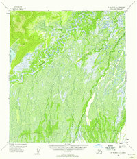
The Kantishna River snakes through a sprawling wetland landscape in this mid-century topographic record of the Alaska interior. The river's tight, intricate meanders dominate the northern terrain, signaling a low-gradient floodplain characterized by seasonal shifts and complex drainage patterns. To the west, the water opens into the significant expanse of Chilchukabena Lake, while several tributaries including Moose Creek, Bear Creek, and Bear Paw Creek feed into the central basin. A notable human element in this largely untracked wilderness is the Sled Road, which provides a rare terrestrial corridor through the brush and marshland. This route reflects the era's reliance on winter-dependent transportation in areas where permanent road infrastructure remained undeveloped, offering a glimpse into how the subarctic landscape was navigated before modern highway expansion.
Find a feature on this map
6 named features on this map. Tap any name to fly to it.
Don’t see what you’re looking for? This feature index may not catch every label — zoom into the map to look around manually.
Map Details
Editions of this 1952 Mount McKinley D-3 Map
3 editions found
Historical Maps of Unorganized Borough Through Time
460 maps found

1949 Fairbanks A-1
Denali Borough, AK

1949 Fairbanks A-2
Denali Borough, AK

1949 Fairbanks B-3
Denali Borough, AK

1949 Fairbanks B-4
Denali Borough, AK

1949 Fairbanks B-5
Denali Borough, AK

1949 Healy B-2
Denali Borough, AK

1949 Healy B-4
Denali Borough, AK

1949 Healy C-3
Denali Borough, AK

1949 Healy D-1
Denali Borough, AK

1950 Fairbanks A-3
Denali Borough, AK

1950 Fairbanks A-4
Denali Borough, AK

1950 Fairbanks A-5
Denali Borough, AK

1950 Fairbanks B-5
Denali Borough, AK

1950 Healy B-3
Denali Borough, AK

1950 Healy B-5
Denali Borough, AK

1950 Healy C-4
Denali Borough, AK

1950 Healy D-3
Denali Borough, AK

1950 Healy D-4
Denali Borough, AK

1951 Fairbanks A-5
Denali Borough, AK

1951 Fairbanks B-5
Denali Borough, AK

1951 Healy B-4
Denali Borough, AK

1951 Healy B-5
Denali Borough, AK

1951 Healy C-1
Denali Borough, AK

1951 Healy C-2
Denali Borough, AK

1951 Healy D-2
Denali Borough, AK

1951 Healy D-5
Denali Borough, AK

1951 Healy D-6
Denali Borough, AK

1951 Mount McKinley D-1
Denali Borough, AK

1952 Fairbanks A-1
Denali Borough, AK

1952 Fairbanks A-2
Denali Borough, AK

1952 Fairbanks A-3
Denali Borough, AK

1952 Fairbanks A-4
Denali Borough, AK

1952 Fairbanks A-6
Denali Borough, AK

1952 Fairbanks B-3
Denali Borough, AK

1952 Fairbanks B-4
Denali Borough, AK

1952 Healy B-2
Denali Borough, AK

1952 Healy B-3
Denali Borough, AK

1952 Healy C-3
Denali Borough, AK

1952 Healy C-4
Denali Borough, AK

1952 Healy C-5
Denali Borough, AK

1952 Healy D-1
Denali Borough, AK

1952 Healy D-2
Denali Borough, AK

1952 Healy D-3
Denali Borough, AK

1952 Healy D-4
Denali Borough, AK

1952 Healy D-5
Denali Borough, AK

1952 Kantishna River A-1
Denali Borough, AK

1952 Kantishna River A-2
Denali Borough, AK

1952 Mount McKinley A-5
Denali Borough, AK

1952 Mount McKinley B-1
Denali Borough, AK

1952 Mount McKinley B-2
Denali Borough, AK

1952 Mount McKinley C-1
Denali Borough, AK

1952 Mount McKinley C-2
Denali Borough, AK

1952 Mount McKinley C-3
Denali Borough, AK

1952 Mount McKinley D-3
Denali Borough, AK

1952 Mount McKinley
Denali Borough, AK

1953 Fairbanks B-6
Denali Borough, AK

1953 Healy B-5
Denali Borough, AK

1953 Healy C-5
Denali Borough, AK

1953 Kantishna River A-1
Denali Borough, AK

1953 Mount McKinley A-4
Denali Borough, AK

1953 Mount McKinley B-3
Denali Borough, AK

1953 Mount McKinley B-4
Denali Borough, AK

1953 Mount McKinley B-5
Denali Borough, AK

1953 Mount McKinley C-4
Denali Borough, AK

1953 Mount McKinley C-5
Denali Borough, AK

1953 Mount McKinley D-4
Denali Borough, AK

1954 Healy C-6
Denali Borough, AK

1954 Healy D-6
Denali Borough, AK

1954 Mount McKinley A-2
Denali Borough, AK

1954 Mount McKinley A-3
Denali Borough, AK

1954 Mount McKinley A-4
Denali Borough, AK

1954 Mount McKinley A-5
Denali Borough, AK

1954 Mount McKinley B-1
Denali Borough, AK

1954 Mount McKinley B-2
Denali Borough, AK

1954 Mount McKinley B-3
Denali Borough, AK

1954 Mount McKinley B-5
Denali Borough, AK

1954 Mount McKinley C-1
Denali Borough, AK

1954 Mount McKinley C-2
Denali Borough, AK

1954 Mount McKinley C-4
Denali Borough, AK

1954 Mount McKinley C-5
Denali Borough, AK

1954 Mount McKinley D-1
Denali Borough, AK

1954 Mount McKinley D-2
Denali Borough, AK

1954 Mount McKinley D-4
Denali Borough, AK

1956 Healy B-5
Denali Borough, AK

1958 Mt McKinley
Denali Borough, AK

1958 Talkeetna D-4
Denali Borough, AK

1958 Talkeetna D-5
Denali Borough, AK

1958 Talkeetna D-6
Denali Borough, AK

1969 Mount McKinley
Denali Borough, AK

1973 Fairbanks A-6
Denali Borough, AK

2013 Fairbanks A-3 NW
Denali Borough, AK

2013 Fairbanks A-4 NE
Denali Borough, AK

2013 Fairbanks A-4 NW
Denali Borough, AK

2013 Fairbanks A-4 SW
Denali Borough, AK

2013 Fairbanks A-5 NE
Denali Borough, AK

2013 Fairbanks A-5 NW
Denali Borough, AK

2013 Fairbanks A-5 SE
Denali Borough, AK

2013 Fairbanks A-5 SW
Denali Borough, AK

2013 Fairbanks A-6 NE
Denali Borough, AK

2013 Fairbanks A-6 NW
Denali Borough, AK

2013 Fairbanks A-6 SE
Denali Borough, AK

2013 Fairbanks A-6 SW
Denali Borough, AK

2013 Fairbanks B-3 SW
Denali Borough, AK

2013 Fairbanks B-4 SE
Denali Borough, AK

2013 Fairbanks B-4 SW
Denali Borough, AK

2013 Fairbanks B-5 SE
Denali Borough, AK

2013 Fairbanks B-5 SW
Denali Borough, AK

2013 Fairbanks B-6 SE
Denali Borough, AK

2013 Fairbanks B-6 SW
Denali Borough, AK

2014 Healy C-6 NW
Denali Borough, AK

2014 Healy C-6 SW
Denali Borough, AK

2014 Healy D-6 NW
Denali Borough, AK

2014 Healy D-6 SW
Denali Borough, AK

2014 Talkeetna D-3 NE
Denali Borough, AK

2014 Talkeetna D-3 NW
Denali Borough, AK

2014 Talkeetna D-4 NE
Denali Borough, AK

2014 Talkeetna D-4 NW
Denali Borough, AK

2014 Talkeetna D-4 SE
Denali Borough, AK

2014 Talkeetna D-4 SW
Denali Borough, AK

2015 Denali A-1 NW
Denali Borough, AK

2015 Denali A-2 NE
Denali Borough, AK

2015 Denali A-2 NW
Denali Borough, AK

2015 Denali A-2 SW
Denali Borough, AK

2015 Denali A-3 NE
Denali Borough, AK

2015 Denali A-3 NW
Denali Borough, AK

2015 Denali A-3 SE
Denali Borough, AK

2015 Denali A-3 SW
Denali Borough, AK

2015 Denali A-4 NE
Denali Borough, AK

2015 Denali A-4 NW
Denali Borough, AK

2015 Denali A-4 SE
Denali Borough, AK

2015 Denali A-4 SW
Denali Borough, AK

2015 Denali B-1 NE
Denali Borough, AK

2015 Denali B-1 NW
Denali Borough, AK

2015 Denali B-1 SW
Denali Borough, AK

2015 Denali B-2 NE
Denali Borough, AK

2015 Denali B-2 NW
Denali Borough, AK

2015 Denali B-2 SE
Denali Borough, AK

2015 Denali B-2 SW
Denali Borough, AK

2015 Denali B-3 NE
Denali Borough, AK

2015 Denali B-3 NW
Denali Borough, AK

2015 Denali B-3 SE
Denali Borough, AK

2015 Denali B-3 SW
Denali Borough, AK

2015 Denali C-1 NE
Denali Borough, AK

2015 Denali C-1 NW
Denali Borough, AK

2015 Denali C-1 SE
Denali Borough, AK

2015 Denali C-1 SW
Denali Borough, AK

2015 Denali C-2 NE
Denali Borough, AK

2015 Denali C-2 NW
Denali Borough, AK

2015 Denali C-2 SE
Denali Borough, AK

2015 Denali C-2 SW
Denali Borough, AK

2015 Denali C-3 NE
Denali Borough, AK

2015 Denali C-3 NW
Denali Borough, AK

2015 Denali C-3 SE
Denali Borough, AK

2015 Denali C-3 SW
Denali Borough, AK

2015 Denali C-4 NE
Denali Borough, AK

2015 Denali C-4 SE
Denali Borough, AK

2015 Denali D-1 NE
Denali Borough, AK

2015 Denali D-1 NW
Denali Borough, AK

2015 Denali D-1 SE
Denali Borough, AK

2015 Denali D-1 SW
Denali Borough, AK

2015 Denali D-2 NE
Denali Borough, AK

2015 Denali D-2 SE
Denali Borough, AK

2015 Denali D-2 SW
Denali Borough, AK

2015 Denali D-3 NW
Denali Borough, AK

2015 Denali D-3 SE
Denali Borough, AK

2015 Denali D-3 SW
Denali Borough, AK

2015 Denali D-4 NE
Denali Borough, AK

2015 Denali D-4 SE
Denali Borough, AK

2016 Denali B-1 SE
Denali Borough, AK

2016 Denali D-2 NW
Denali Borough, AK

2016 Denali D-3 NE
Denali Borough, AK

2016 Fairbanks A-1 NE
Denali Borough, AK

2016 Fairbanks A-1 NW
Denali Borough, AK

2016 Fairbanks A-1 SE
Denali Borough, AK

2016 Fairbanks A-1 SW
Denali Borough, AK

2016 Fairbanks A-2 NE
Denali Borough, AK

2016 Fairbanks A-2 NW
Denali Borough, AK

2016 Fairbanks A-2 SE
Denali Borough, AK

2016 Fairbanks A-2 SW
Denali Borough, AK

2016 Fairbanks A-3 NE
Denali Borough, AK

2016 Fairbanks A-3 SE
Denali Borough, AK

2016 Fairbanks A-3 SW
Denali Borough, AK

2016 Fairbanks B-3 SE
Denali Borough, AK

2016 Healy A-3 NE
Denali Borough, AK

2016 Healy A-3 NW
Denali Borough, AK

2016 Healy A-4 NE
Denali Borough, AK

2016 Healy B-2 NW
Denali Borough, AK

2016 Healy B-2 SW
Denali Borough, AK

2016 Healy B-3 NE
Denali Borough, AK

2016 Healy B-3 NW
Denali Borough, AK

2016 Healy B-3 SE
Denali Borough, AK

2016 Healy B-3 SW
Denali Borough, AK

2016 Healy B-4 NE
Denali Borough, AK

2016 Healy B-4 NW
Denali Borough, AK

2016 Healy B-4 SE
Denali Borough, AK

2016 Healy B-5 NE
Denali Borough, AK

2016 Healy B-5 NW
Denali Borough, AK

2016 Healy B-6 NE
Denali Borough, AK

2016 Healy B-6 NW
Denali Borough, AK

2016 Healy C-1 NE
Denali Borough, AK

2016 Healy C-1 NW
Denali Borough, AK

2016 Healy C-2 NE
Denali Borough, AK

2016 Healy C-2 NW
Denali Borough, AK

2016 Healy C-2 SE
Denali Borough, AK

2016 Healy C-2 SW
Denali Borough, AK

2016 Healy C-3 NE
Denali Borough, AK

2016 Healy C-3 NW
Denali Borough, AK

2016 Healy C-3 SE
Denali Borough, AK

2016 Healy C-3 SW
Denali Borough, AK

2016 Healy C-4 NE
Denali Borough, AK

2016 Healy C-4 NW
Denali Borough, AK

2016 Healy C-4 SE
Denali Borough, AK

2016 Healy C-4 SW
Denali Borough, AK

2016 Healy C-5 NE
Denali Borough, AK

2016 Healy C-5 NW
Denali Borough, AK

2016 Healy C-5 SE
Denali Borough, AK

2016 Healy C-5 SW
Denali Borough, AK

2016 Healy C-6 NE
Denali Borough, AK

2016 Healy C-6 SE
Denali Borough, AK

2016 Healy D-1 NE
Denali Borough, AK

2016 Healy D-1 NW
Denali Borough, AK

2016 Healy D-1 SE
Denali Borough, AK

2016 Healy D-1 SW
Denali Borough, AK

2016 Healy D-2 NE
Denali Borough, AK

2016 Healy D-2 NW
Denali Borough, AK

2016 Healy D-2 SE
Denali Borough, AK

2016 Healy D-2 SW
Denali Borough, AK

2016 Healy D-3 NE
Denali Borough, AK

2016 Healy D-3 NW
Denali Borough, AK

2016 Healy D-3 SE
Denali Borough, AK

2016 Healy D-3 SW
Denali Borough, AK

2016 Healy D-4 NE
Denali Borough, AK

2016 Healy D-4 NW
Denali Borough, AK

2016 Healy D-4 SE
Denali Borough, AK

2016 Healy D-4 SW
Denali Borough, AK

2016 Healy D-5 NE
Denali Borough, AK

2016 Healy D-5 NW
Denali Borough, AK

2016 Healy D-5 SE
Denali Borough, AK

2016 Healy D-5 SW
Denali Borough, AK

2016 Healy D-6 NE
Denali Borough, AK

2016 Healy D-6 SE
Denali Borough, AK

2017 Denali A-5 NE
Denali Borough, AK

2017 Denali A-5 NW
Denali Borough, AK

2017 Denali A-5 SE
Denali Borough, AK

2017 Denali A-5 SW
Denali Borough, AK

2017 Denali A-6 NE
Denali Borough, AK

2017 Denali A-6 NW
Denali Borough, AK

2017 Denali A-6 SE
Denali Borough, AK

2017 Denali A-6 SW
Denali Borough, AK

2017 Denali B-4 NE
Denali Borough, AK

2017 Denali B-4 NW
Denali Borough, AK

2017 Denali B-4 SE
Denali Borough, AK

2017 Denali B-4 SW
Denali Borough, AK

2017 Denali B-5 NE
Denali Borough, AK

2017 Denali B-5 NW
Denali Borough, AK

2017 Denali B-5 SE
Denali Borough, AK

2017 Denali B-5 SW
Denali Borough, AK

2017 Denali B-6 NE
Denali Borough, AK

2017 Denali B-6 NW
Denali Borough, AK

2017 Denali B-6 SE
Denali Borough, AK

2017 Denali B-6 SW
Denali Borough, AK

2017 Denali C-4 NW
Denali Borough, AK

2017 Denali C-4 SW
Denali Borough, AK

2017 Denali C-5 NE
Denali Borough, AK

2017 Denali C-5 NW
Denali Borough, AK

2017 Denali C-5 SE
Denali Borough, AK

2017 Denali C-5 SW
Denali Borough, AK

2017 Denali C-6 NE
Denali Borough, AK

2017 Denali C-6 NW
Denali Borough, AK

2017 Denali C-6 SE
Denali Borough, AK

2017 Denali C-6 SW
Denali Borough, AK

2017 Denali D-4 NW
Denali Borough, AK

2017 Denali D-4 SW
Denali Borough, AK

2017 Denali D-5 NE
Denali Borough, AK

2017 Denali D-5 NW
Denali Borough, AK

2017 Denali D-5 SE
Denali Borough, AK

2017 Denali D-5 SW
Denali Borough, AK

2017 Denali D-6 NE
Denali Borough, AK

2017 Denali D-6 NW
Denali Borough, AK

2017 Denali D-6 SE
Denali Borough, AK

2017 Denali D-6 SW
Denali Borough, AK

2017 Fairbanks A-4 SE
Denali Borough, AK

2017 Kantishna River A-1 NE
Denali Borough, AK

2017 Kantishna River A-1 NW
Denali Borough, AK

2017 Kantishna River A-1 SE
Denali Borough, AK

2017 Kantishna River A-1 SW
Denali Borough, AK

2017 Kantishna River A-2 NE
Denali Borough, AK

2017 Kantishna River A-2 NW
Denali Borough, AK

2017 Kantishna River A-2 SE
Denali Borough, AK

2017 Kantishna River A-2 SW
Denali Borough, AK

2017 Kantishna River A-3 SE
Denali Borough, AK

2017 Kantishna River A-4 SE
Denali Borough, AK

2017 Kantishna River B-1 SE
Denali Borough, AK

2017 Kantishna River B-1 SW
Denali Borough, AK

2017 Kantishna River B-2 SE
Denali Borough, AK

2017 Talkeetna D-5 NE
Denali Borough, AK

2017 Talkeetna D-5 NW
Denali Borough, AK

2017 Talkeetna D-5 SE
Denali Borough, AK

2017 Talkeetna D-5 SW
Denali Borough, AK

2017 Talkeetna D-6 NE
Denali Borough, AK

2017 Talkeetna D-6 NW
Denali Borough, AK

2017 Talkeetna D-6 SE
Denali Borough, AK

2017 Talkeetna D-6 SW
Denali Borough, AK

2019 Denali B-1 NE
Denali Borough, AK

2019 Denali B-1 NW
Denali Borough, AK

2019 Denali B-2 NE
Denali Borough, AK

2019 Denali B-2 NW
Denali Borough, AK

2019 Denali C-1 SE
Denali Borough, AK

2019 Denali C-2 SE
Denali Borough, AK

2019 Denali C-2 SW
Denali Borough, AK

2019 Healy B-4 NW
Denali Borough, AK

2019 Healy B-5 NE
Denali Borough, AK

2019 Healy C-4 NW
Denali Borough, AK

2019 Healy C-5 NE
Denali Borough, AK

2019 Healy C-5 NW
Denali Borough, AK

2019 Healy C-6 NE
Denali Borough, AK

2019 Healy C-6 SE
Denali Borough, AK

2019 Healy C-6 SW
Denali Borough, AK

2019 Healy D-4 SW
Denali Borough, AK

2019 Healy D-5 SW
Denali Borough, AK

2023 Denali A-1 NW
Denali Borough, AK

2023 Denali A-2 NE
Denali Borough, AK

2023 Denali A-2 NW
Denali Borough, AK

2023 Denali A-2 SW
Denali Borough, AK

2023 Denali A-3 NE
Denali Borough, AK

2023 Denali A-3 NW
Denali Borough, AK

2023 Denali A-3 SE
Denali Borough, AK

2023 Denali A-3 SW
Denali Borough, AK

2023 Denali A-4 NE
Denali Borough, AK

2023 Denali A-4 NW
Denali Borough, AK

2023 Denali A-4 SE
Denali Borough, AK

2023 Denali A-4 SW
Denali Borough, AK

2023 Denali A-5 NE
Denali Borough, AK

2023 Denali A-5 NW
Denali Borough, AK

2023 Denali A-5 SE
Denali Borough, AK

2023 Denali A-5 SW
Denali Borough, AK

2023 Denali A-6 NE
Denali Borough, AK

2023 Denali A-6 NW
Denali Borough, AK

2023 Denali A-6 SE
Denali Borough, AK

2023 Denali A-6 SW
Denali Borough, AK

2023 Denali B-1 NE
Denali Borough, AK

2023 Denali B-1 NW
Denali Borough, AK

2023 Denali B-1 SE
Denali Borough, AK

2023 Denali B-1 SW
Denali Borough, AK

2023 Denali B-2 NE
Denali Borough, AK

2023 Denali B-2 NW
Denali Borough, AK

2023 Denali B-2 SE
Denali Borough, AK

2023 Denali B-2 SW
Denali Borough, AK

2023 Denali B-3 NE
Denali Borough, AK

2023 Denali B-3 NW
Denali Borough, AK

2023 Denali B-3 SE
Denali Borough, AK

2023 Denali B-3 SW
Denali Borough, AK

2023 Denali B-4 NE
Denali Borough, AK

2023 Denali B-4 NW
Denali Borough, AK

2023 Denali B-4 SE
Denali Borough, AK

2023 Denali B-4 SW
Denali Borough, AK

2023 Denali B-5 NE
Denali Borough, AK

2023 Denali B-5 NW
Denali Borough, AK

2023 Denali B-5 SE
Denali Borough, AK

2023 Denali B-5 SW
Denali Borough, AK

2023 Denali B-6 NE
Denali Borough, AK

2023 Denali B-6 NW
Denali Borough, AK

2023 Denali B-6 SE
Denali Borough, AK

2023 Denali B-6 SW
Denali Borough, AK

2023 Denali C-1 NE
Denali Borough, AK

2023 Denali C-1 NW
Denali Borough, AK

2023 Denali C-1 SE
Denali Borough, AK

2023 Denali C-1 SW
Denali Borough, AK

2023 Denali C-2 NE
Denali Borough, AK

2023 Denali C-2 NW
Denali Borough, AK

2023 Denali C-2 SE
Denali Borough, AK

2023 Denali C-2 SW
Denali Borough, AK

2023 Denali C-3 NE
Denali Borough, AK

2023 Denali C-3 NW
Denali Borough, AK

2023 Denali C-3 SE
Denali Borough, AK

2023 Denali C-3 SW
Denali Borough, AK

2023 Denali C-4 NE
Denali Borough, AK

2023 Denali C-4 NW
Denali Borough, AK

2023 Denali C-4 SE
Denali Borough, AK

2023 Denali C-4 SW
Denali Borough, AK

2023 Denali C-5 NE
Denali Borough, AK

2023 Denali C-5 NW
Denali Borough, AK

2023 Denali C-5 SE
Denali Borough, AK

2023 Denali C-5 SW
Denali Borough, AK

2023 Denali C-6 NE
Denali Borough, AK

2023 Denali C-6 NW
Denali Borough, AK

2023 Denali C-6 SE
Denali Borough, AK

2023 Denali C-6 SW
Denali Borough, AK

2023 Denali D-1 NE
Denali Borough, AK

2023 Denali D-1 NW
Denali Borough, AK

2023 Denali D-1 SE
Denali Borough, AK

2023 Denali D-1 SW
Denali Borough, AK

2023 Denali D-2 NE
Denali Borough, AK

2023 Denali D-2 NW
Denali Borough, AK

2023 Denali D-2 SE
Denali Borough, AK

2023 Denali D-2 SW
Denali Borough, AK

2023 Denali D-3 NE
Denali Borough, AK

2023 Denali D-3 NW
Denali Borough, AK

2023 Denali D-3 SE
Denali Borough, AK

2023 Denali D-3 SW
Denali Borough, AK

2023 Denali D-4 NE
Denali Borough, AK

2023 Denali D-4 NW
Denali Borough, AK

2023 Denali D-4 SE
Denali Borough, AK

2023 Denali D-4 SW
Denali Borough, AK

2023 Denali D-5 NE
Denali Borough, AK

2023 Denali D-5 NW
Denali Borough, AK

2023 Denali D-5 SE
Denali Borough, AK

2023 Denali D-5 SW
Denali Borough, AK

2023 Denali D-6 NE
Denali Borough, AK

2023 Denali D-6 NW
Denali Borough, AK

2023 Denali D-6 SE
Denali Borough, AK

2023 Denali D-6 SW
Denali Borough, AK

2023 Talkeetna D-3 NE
Denali Borough, AK

2023 Talkeetna D-3 NW
Denali Borough, AK

2023 Talkeetna D-4 NE
Denali Borough, AK

2023 Talkeetna D-4 NW
Denali Borough, AK

2023 Talkeetna D-4 SE
Denali Borough, AK

2023 Talkeetna D-4 SW
Denali Borough, AK

2024 Fairbanks A-6 NW
Denali Borough, AK

2024 Fairbanks A-6 SE
Denali Borough, AK

2024 Fairbanks A-6 SW
Denali Borough, AK

2024 Fairbanks B-6 SW
Denali Borough, AK

2024 Healy A-3 NE
Denali Borough, AK

2024 Healy A-3 NW
Denali Borough, AK

2024 Healy A-4 NE
Denali Borough, AK

2024 Healy B-5 NW
Denali Borough, AK

2024 Healy B-6 NE
Denali Borough, AK

2024 Healy B-6 NW
Denali Borough, AK

2024 Healy C-2 SE
Denali Borough, AK

2024 Healy C-6 NE
Denali Borough, AK

2024 Healy C-6 NW
Denali Borough, AK

2024 Healy C-6 SE
Denali Borough, AK

2024 Healy C-6 SW
Denali Borough, AK

2024 Healy D-6 NE
Denali Borough, AK

2024 Healy D-6 NW
Denali Borough, AK

2024 Healy D-6 SE
Denali Borough, AK

2024 Healy D-6 SW
Denali Borough, AK

2024 Kantishna River A-1 NE
Denali Borough, AK

2024 Kantishna River A-1 NW
Denali Borough, AK

2024 Kantishna River A-1 SE
Denali Borough, AK

2024 Kantishna River A-1 SW
Denali Borough, AK

2024 Kantishna River A-2 NE
Denali Borough, AK

2024 Kantishna River A-2 NW
Denali Borough, AK

2024 Kantishna River A-2 SE
Denali Borough, AK

2024 Kantishna River A-2 SW
Denali Borough, AK

2024 Kantishna River A-3 SE
Denali Borough, AK

2024 Kantishna River A-4 SE
Denali Borough, AK

2024 Kantishna River B-1 SE
Denali Borough, AK

2024 Kantishna River B-1 SW
Denali Borough, AK

2024 Kantishna River B-2 SE
Denali Borough, AK

2024 Talkeetna D-5 NE
Denali Borough, AK

2024 Talkeetna D-5 NW
Denali Borough, AK

2024 Talkeetna D-5 SE
Denali Borough, AK

2024 Talkeetna D-5 SW
Denali Borough, AK

2024 Talkeetna D-6 NE
Denali Borough, AK

2024 Talkeetna D-6 NW
Denali Borough, AK

2024 Talkeetna D-6 SE
Denali Borough, AK

2024 Talkeetna D-6 SW
Denali Borough, AK

2025 Denali A-2 SW
Denali Borough, AK

2025 Denali A-3 SE
Denali Borough, AK