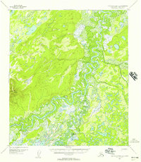
1952 Map of Kantishna River A-2
USGS Topo · Published 1957About this map
Kantishna River and Bearpaw River dominate this interior Alaskan landscape, weaving through a dense network of wetlands and small lakes. The 1952 aerial photography captured a remote wilderness where transport relied on the winding waterways and the seasonal Sled Road that crosses the eastern terrain. Bearpaw Cabins sits as a primary point of human settlement along the riverbanks, representing the small-scale habitations typical of the Fourth Judicial Division in the mid-20th century. To the west, the elevation rises toward Bearpaw Mountain, providing a stark contrast to the low-lying marshlands of the Chitsia Creek drainage. The map provides a distinct look at the topographic character of the region before significant modern development, documenting the exact placement of river meanders and localized landmarks used by trappers and early explorers.
Find a feature on this map
6 named features on this map. Tap any name to fly to it.
Don’t see what you’re looking for? This feature index may not catch every label — zoom into the map to look around manually.
Map Details
Editions of this 1952 Kantishna River A-2 Map
4 editions found
Historical Maps of Unorganized Borough Through Time
460 maps found

1949 Fairbanks A-1
Denali Borough, AK

1949 Fairbanks A-2
Denali Borough, AK

1949 Fairbanks B-3
Denali Borough, AK

1949 Fairbanks B-4
Denali Borough, AK

1949 Fairbanks B-5
Denali Borough, AK

1949 Healy B-2
Denali Borough, AK

1949 Healy B-4
Denali Borough, AK

1949 Healy C-3
Denali Borough, AK

1949 Healy D-1
Denali Borough, AK

1950 Fairbanks A-3
Denali Borough, AK

1950 Fairbanks A-4
Denali Borough, AK

1950 Fairbanks A-5
Denali Borough, AK

1950 Fairbanks B-5
Denali Borough, AK

1950 Healy B-3
Denali Borough, AK

1950 Healy B-5
Denali Borough, AK

1950 Healy C-4
Denali Borough, AK

1950 Healy D-3
Denali Borough, AK

1950 Healy D-4
Denali Borough, AK

1951 Fairbanks A-5
Denali Borough, AK

1951 Fairbanks B-5
Denali Borough, AK

1951 Healy B-4
Denali Borough, AK

1951 Healy B-5
Denali Borough, AK

1951 Healy C-1
Denali Borough, AK

1951 Healy C-2
Denali Borough, AK

1951 Healy D-2
Denali Borough, AK

1951 Healy D-5
Denali Borough, AK

1951 Healy D-6
Denali Borough, AK

1951 Mount McKinley D-1
Denali Borough, AK

1952 Fairbanks A-1
Denali Borough, AK

1952 Fairbanks A-2
Denali Borough, AK

1952 Fairbanks A-3
Denali Borough, AK

1952 Fairbanks A-4
Denali Borough, AK

1952 Fairbanks A-6
Denali Borough, AK

1952 Fairbanks B-3
Denali Borough, AK

1952 Fairbanks B-4
Denali Borough, AK

1952 Healy B-2
Denali Borough, AK

1952 Healy B-3
Denali Borough, AK

1952 Healy C-3
Denali Borough, AK

1952 Healy C-4
Denali Borough, AK

1952 Healy C-5
Denali Borough, AK

1952 Healy D-1
Denali Borough, AK

1952 Healy D-2
Denali Borough, AK

1952 Healy D-3
Denali Borough, AK

1952 Healy D-4
Denali Borough, AK

1952 Healy D-5
Denali Borough, AK

1952 Kantishna River A-1
Denali Borough, AK

1952 Kantishna River A-2
Denali Borough, AK

1952 Mount McKinley A-5
Denali Borough, AK

1952 Mount McKinley B-1
Denali Borough, AK

1952 Mount McKinley B-2
Denali Borough, AK

1952 Mount McKinley C-1
Denali Borough, AK

1952 Mount McKinley C-2
Denali Borough, AK

1952 Mount McKinley C-3
Denali Borough, AK

1952 Mount McKinley D-3
Denali Borough, AK

1952 Mount McKinley
Denali Borough, AK

1953 Fairbanks B-6
Denali Borough, AK

1953 Healy B-5
Denali Borough, AK

1953 Healy C-5
Denali Borough, AK

1953 Kantishna River A-1
Denali Borough, AK

1953 Mount McKinley A-4
Denali Borough, AK

1953 Mount McKinley B-3
Denali Borough, AK

1953 Mount McKinley B-4
Denali Borough, AK

1953 Mount McKinley B-5
Denali Borough, AK

1953 Mount McKinley C-4
Denali Borough, AK

1953 Mount McKinley C-5
Denali Borough, AK

1953 Mount McKinley D-4
Denali Borough, AK

1954 Healy C-6
Denali Borough, AK

1954 Healy D-6
Denali Borough, AK

1954 Mount McKinley A-2
Denali Borough, AK

1954 Mount McKinley A-3
Denali Borough, AK

1954 Mount McKinley A-4
Denali Borough, AK

1954 Mount McKinley A-5
Denali Borough, AK

1954 Mount McKinley B-1
Denali Borough, AK

1954 Mount McKinley B-2
Denali Borough, AK

1954 Mount McKinley B-3
Denali Borough, AK

1954 Mount McKinley B-5
Denali Borough, AK

1954 Mount McKinley C-1
Denali Borough, AK

1954 Mount McKinley C-2
Denali Borough, AK

1954 Mount McKinley C-4
Denali Borough, AK

1954 Mount McKinley C-5
Denali Borough, AK

1954 Mount McKinley D-1
Denali Borough, AK

1954 Mount McKinley D-2
Denali Borough, AK

1954 Mount McKinley D-4
Denali Borough, AK

1956 Healy B-5
Denali Borough, AK

1958 Mt McKinley
Denali Borough, AK

1958 Talkeetna D-4
Denali Borough, AK

1958 Talkeetna D-5
Denali Borough, AK

1958 Talkeetna D-6
Denali Borough, AK

1969 Mount McKinley
Denali Borough, AK

1973 Fairbanks A-6
Denali Borough, AK

2013 Fairbanks A-3 NW
Denali Borough, AK

2013 Fairbanks A-4 NE
Denali Borough, AK

2013 Fairbanks A-4 NW
Denali Borough, AK

2013 Fairbanks A-4 SW
Denali Borough, AK

2013 Fairbanks A-5 NE
Denali Borough, AK

2013 Fairbanks A-5 NW
Denali Borough, AK

2013 Fairbanks A-5 SE
Denali Borough, AK

2013 Fairbanks A-5 SW
Denali Borough, AK

2013 Fairbanks A-6 NE
Denali Borough, AK

2013 Fairbanks A-6 NW
Denali Borough, AK

2013 Fairbanks A-6 SE
Denali Borough, AK

2013 Fairbanks A-6 SW
Denali Borough, AK

2013 Fairbanks B-3 SW
Denali Borough, AK

2013 Fairbanks B-4 SE
Denali Borough, AK

2013 Fairbanks B-4 SW
Denali Borough, AK

2013 Fairbanks B-5 SE
Denali Borough, AK

2013 Fairbanks B-5 SW
Denali Borough, AK

2013 Fairbanks B-6 SE
Denali Borough, AK

2013 Fairbanks B-6 SW
Denali Borough, AK

2014 Healy C-6 NW
Denali Borough, AK

2014 Healy C-6 SW
Denali Borough, AK

2014 Healy D-6 NW
Denali Borough, AK

2014 Healy D-6 SW
Denali Borough, AK

2014 Talkeetna D-3 NE
Denali Borough, AK

2014 Talkeetna D-3 NW
Denali Borough, AK

2014 Talkeetna D-4 NE
Denali Borough, AK

2014 Talkeetna D-4 NW
Denali Borough, AK

2014 Talkeetna D-4 SE
Denali Borough, AK

2014 Talkeetna D-4 SW
Denali Borough, AK

2015 Denali A-1 NW
Denali Borough, AK

2015 Denali A-2 NE
Denali Borough, AK

2015 Denali A-2 NW
Denali Borough, AK

2015 Denali A-2 SW
Denali Borough, AK

2015 Denali A-3 NE
Denali Borough, AK

2015 Denali A-3 NW
Denali Borough, AK

2015 Denali A-3 SE
Denali Borough, AK

2015 Denali A-3 SW
Denali Borough, AK

2015 Denali A-4 NE
Denali Borough, AK

2015 Denali A-4 NW
Denali Borough, AK

2015 Denali A-4 SE
Denali Borough, AK

2015 Denali A-4 SW
Denali Borough, AK

2015 Denali B-1 NE
Denali Borough, AK

2015 Denali B-1 NW
Denali Borough, AK

2015 Denali B-1 SW
Denali Borough, AK

2015 Denali B-2 NE
Denali Borough, AK

2015 Denali B-2 NW
Denali Borough, AK

2015 Denali B-2 SE
Denali Borough, AK

2015 Denali B-2 SW
Denali Borough, AK

2015 Denali B-3 NE
Denali Borough, AK

2015 Denali B-3 NW
Denali Borough, AK

2015 Denali B-3 SE
Denali Borough, AK

2015 Denali B-3 SW
Denali Borough, AK

2015 Denali C-1 NE
Denali Borough, AK

2015 Denali C-1 NW
Denali Borough, AK

2015 Denali C-1 SE
Denali Borough, AK

2015 Denali C-1 SW
Denali Borough, AK

2015 Denali C-2 NE
Denali Borough, AK

2015 Denali C-2 NW
Denali Borough, AK

2015 Denali C-2 SE
Denali Borough, AK

2015 Denali C-2 SW
Denali Borough, AK

2015 Denali C-3 NE
Denali Borough, AK

2015 Denali C-3 NW
Denali Borough, AK

2015 Denali C-3 SE
Denali Borough, AK

2015 Denali C-3 SW
Denali Borough, AK

2015 Denali C-4 NE
Denali Borough, AK

2015 Denali C-4 SE
Denali Borough, AK

2015 Denali D-1 NE
Denali Borough, AK

2015 Denali D-1 NW
Denali Borough, AK

2015 Denali D-1 SE
Denali Borough, AK

2015 Denali D-1 SW
Denali Borough, AK

2015 Denali D-2 NE
Denali Borough, AK

2015 Denali D-2 SE
Denali Borough, AK

2015 Denali D-2 SW
Denali Borough, AK

2015 Denali D-3 NW
Denali Borough, AK

2015 Denali D-3 SE
Denali Borough, AK

2015 Denali D-3 SW
Denali Borough, AK

2015 Denali D-4 NE
Denali Borough, AK

2015 Denali D-4 SE
Denali Borough, AK

2016 Denali B-1 SE
Denali Borough, AK

2016 Denali D-2 NW
Denali Borough, AK

2016 Denali D-3 NE
Denali Borough, AK

2016 Fairbanks A-1 NE
Denali Borough, AK

2016 Fairbanks A-1 NW
Denali Borough, AK

2016 Fairbanks A-1 SE
Denali Borough, AK

2016 Fairbanks A-1 SW
Denali Borough, AK

2016 Fairbanks A-2 NE
Denali Borough, AK

2016 Fairbanks A-2 NW
Denali Borough, AK

2016 Fairbanks A-2 SE
Denali Borough, AK

2016 Fairbanks A-2 SW
Denali Borough, AK

2016 Fairbanks A-3 NE
Denali Borough, AK

2016 Fairbanks A-3 SE
Denali Borough, AK

2016 Fairbanks A-3 SW
Denali Borough, AK

2016 Fairbanks B-3 SE
Denali Borough, AK

2016 Healy A-3 NE
Denali Borough, AK

2016 Healy A-3 NW
Denali Borough, AK

2016 Healy A-4 NE
Denali Borough, AK

2016 Healy B-2 NW
Denali Borough, AK

2016 Healy B-2 SW
Denali Borough, AK

2016 Healy B-3 NE
Denali Borough, AK

2016 Healy B-3 NW
Denali Borough, AK

2016 Healy B-3 SE
Denali Borough, AK

2016 Healy B-3 SW
Denali Borough, AK

2016 Healy B-4 NE
Denali Borough, AK

2016 Healy B-4 NW
Denali Borough, AK

2016 Healy B-4 SE
Denali Borough, AK

2016 Healy B-5 NE
Denali Borough, AK

2016 Healy B-5 NW
Denali Borough, AK

2016 Healy B-6 NE
Denali Borough, AK

2016 Healy B-6 NW
Denali Borough, AK

2016 Healy C-1 NE
Denali Borough, AK

2016 Healy C-1 NW
Denali Borough, AK

2016 Healy C-2 NE
Denali Borough, AK

2016 Healy C-2 NW
Denali Borough, AK

2016 Healy C-2 SE
Denali Borough, AK

2016 Healy C-2 SW
Denali Borough, AK

2016 Healy C-3 NE
Denali Borough, AK

2016 Healy C-3 NW
Denali Borough, AK

2016 Healy C-3 SE
Denali Borough, AK

2016 Healy C-3 SW
Denali Borough, AK

2016 Healy C-4 NE
Denali Borough, AK

2016 Healy C-4 NW
Denali Borough, AK

2016 Healy C-4 SE
Denali Borough, AK

2016 Healy C-4 SW
Denali Borough, AK

2016 Healy C-5 NE
Denali Borough, AK

2016 Healy C-5 NW
Denali Borough, AK

2016 Healy C-5 SE
Denali Borough, AK

2016 Healy C-5 SW
Denali Borough, AK

2016 Healy C-6 NE
Denali Borough, AK

2016 Healy C-6 SE
Denali Borough, AK

2016 Healy D-1 NE
Denali Borough, AK

2016 Healy D-1 NW
Denali Borough, AK

2016 Healy D-1 SE
Denali Borough, AK

2016 Healy D-1 SW
Denali Borough, AK

2016 Healy D-2 NE
Denali Borough, AK

2016 Healy D-2 NW
Denali Borough, AK

2016 Healy D-2 SE
Denali Borough, AK

2016 Healy D-2 SW
Denali Borough, AK

2016 Healy D-3 NE
Denali Borough, AK

2016 Healy D-3 NW
Denali Borough, AK

2016 Healy D-3 SE
Denali Borough, AK

2016 Healy D-3 SW
Denali Borough, AK

2016 Healy D-4 NE
Denali Borough, AK

2016 Healy D-4 NW
Denali Borough, AK

2016 Healy D-4 SE
Denali Borough, AK

2016 Healy D-4 SW
Denali Borough, AK

2016 Healy D-5 NE
Denali Borough, AK

2016 Healy D-5 NW
Denali Borough, AK

2016 Healy D-5 SE
Denali Borough, AK

2016 Healy D-5 SW
Denali Borough, AK

2016 Healy D-6 NE
Denali Borough, AK

2016 Healy D-6 SE
Denali Borough, AK

2017 Denali A-5 NE
Denali Borough, AK

2017 Denali A-5 NW
Denali Borough, AK

2017 Denali A-5 SE
Denali Borough, AK

2017 Denali A-5 SW
Denali Borough, AK

2017 Denali A-6 NE
Denali Borough, AK

2017 Denali A-6 NW
Denali Borough, AK

2017 Denali A-6 SE
Denali Borough, AK

2017 Denali A-6 SW
Denali Borough, AK

2017 Denali B-4 NE
Denali Borough, AK

2017 Denali B-4 NW
Denali Borough, AK

2017 Denali B-4 SE
Denali Borough, AK

2017 Denali B-4 SW
Denali Borough, AK

2017 Denali B-5 NE
Denali Borough, AK

2017 Denali B-5 NW
Denali Borough, AK

2017 Denali B-5 SE
Denali Borough, AK

2017 Denali B-5 SW
Denali Borough, AK

2017 Denali B-6 NE
Denali Borough, AK

2017 Denali B-6 NW
Denali Borough, AK

2017 Denali B-6 SE
Denali Borough, AK

2017 Denali B-6 SW
Denali Borough, AK

2017 Denali C-4 NW
Denali Borough, AK

2017 Denali C-4 SW
Denali Borough, AK

2017 Denali C-5 NE
Denali Borough, AK

2017 Denali C-5 NW
Denali Borough, AK

2017 Denali C-5 SE
Denali Borough, AK

2017 Denali C-5 SW
Denali Borough, AK

2017 Denali C-6 NE
Denali Borough, AK

2017 Denali C-6 NW
Denali Borough, AK

2017 Denali C-6 SE
Denali Borough, AK

2017 Denali C-6 SW
Denali Borough, AK

2017 Denali D-4 NW
Denali Borough, AK

2017 Denali D-4 SW
Denali Borough, AK

2017 Denali D-5 NE
Denali Borough, AK

2017 Denali D-5 NW
Denali Borough, AK

2017 Denali D-5 SE
Denali Borough, AK

2017 Denali D-5 SW
Denali Borough, AK

2017 Denali D-6 NE
Denali Borough, AK

2017 Denali D-6 NW
Denali Borough, AK

2017 Denali D-6 SE
Denali Borough, AK

2017 Denali D-6 SW
Denali Borough, AK

2017 Fairbanks A-4 SE
Denali Borough, AK

2017 Kantishna River A-1 NE
Denali Borough, AK

2017 Kantishna River A-1 NW
Denali Borough, AK

2017 Kantishna River A-1 SE
Denali Borough, AK

2017 Kantishna River A-1 SW
Denali Borough, AK

2017 Kantishna River A-2 NE
Denali Borough, AK

2017 Kantishna River A-2 NW
Denali Borough, AK

2017 Kantishna River A-2 SE
Denali Borough, AK

2017 Kantishna River A-2 SW
Denali Borough, AK

2017 Kantishna River A-3 SE
Denali Borough, AK

2017 Kantishna River A-4 SE
Denali Borough, AK

2017 Kantishna River B-1 SE
Denali Borough, AK

2017 Kantishna River B-1 SW
Denali Borough, AK

2017 Kantishna River B-2 SE
Denali Borough, AK

2017 Talkeetna D-5 NE
Denali Borough, AK

2017 Talkeetna D-5 NW
Denali Borough, AK

2017 Talkeetna D-5 SE
Denali Borough, AK

2017 Talkeetna D-5 SW
Denali Borough, AK

2017 Talkeetna D-6 NE
Denali Borough, AK

2017 Talkeetna D-6 NW
Denali Borough, AK

2017 Talkeetna D-6 SE
Denali Borough, AK

2017 Talkeetna D-6 SW
Denali Borough, AK

2019 Denali B-1 NE
Denali Borough, AK

2019 Denali B-1 NW
Denali Borough, AK

2019 Denali B-2 NE
Denali Borough, AK

2019 Denali B-2 NW
Denali Borough, AK

2019 Denali C-1 SE
Denali Borough, AK

2019 Denali C-2 SE
Denali Borough, AK

2019 Denali C-2 SW
Denali Borough, AK

2019 Healy B-4 NW
Denali Borough, AK

2019 Healy B-5 NE
Denali Borough, AK

2019 Healy C-4 NW
Denali Borough, AK

2019 Healy C-5 NE
Denali Borough, AK

2019 Healy C-5 NW
Denali Borough, AK

2019 Healy C-6 NE
Denali Borough, AK

2019 Healy C-6 SE
Denali Borough, AK

2019 Healy C-6 SW
Denali Borough, AK

2019 Healy D-4 SW
Denali Borough, AK

2019 Healy D-5 SW
Denali Borough, AK

2023 Denali A-1 NW
Denali Borough, AK

2023 Denali A-2 NE
Denali Borough, AK

2023 Denali A-2 NW
Denali Borough, AK

2023 Denali A-2 SW
Denali Borough, AK

2023 Denali A-3 NE
Denali Borough, AK

2023 Denali A-3 NW
Denali Borough, AK

2023 Denali A-3 SE
Denali Borough, AK

2023 Denali A-3 SW
Denali Borough, AK

2023 Denali A-4 NE
Denali Borough, AK

2023 Denali A-4 NW
Denali Borough, AK

2023 Denali A-4 SE
Denali Borough, AK

2023 Denali A-4 SW
Denali Borough, AK

2023 Denali A-5 NE
Denali Borough, AK

2023 Denali A-5 NW
Denali Borough, AK

2023 Denali A-5 SE
Denali Borough, AK

2023 Denali A-5 SW
Denali Borough, AK

2023 Denali A-6 NE
Denali Borough, AK

2023 Denali A-6 NW
Denali Borough, AK

2023 Denali A-6 SE
Denali Borough, AK

2023 Denali A-6 SW
Denali Borough, AK

2023 Denali B-1 NE
Denali Borough, AK

2023 Denali B-1 NW
Denali Borough, AK

2023 Denali B-1 SE
Denali Borough, AK

2023 Denali B-1 SW
Denali Borough, AK

2023 Denali B-2 NE
Denali Borough, AK

2023 Denali B-2 NW
Denali Borough, AK

2023 Denali B-2 SE
Denali Borough, AK

2023 Denali B-2 SW
Denali Borough, AK

2023 Denali B-3 NE
Denali Borough, AK

2023 Denali B-3 NW
Denali Borough, AK

2023 Denali B-3 SE
Denali Borough, AK

2023 Denali B-3 SW
Denali Borough, AK

2023 Denali B-4 NE
Denali Borough, AK

2023 Denali B-4 NW
Denali Borough, AK

2023 Denali B-4 SE
Denali Borough, AK

2023 Denali B-4 SW
Denali Borough, AK

2023 Denali B-5 NE
Denali Borough, AK

2023 Denali B-5 NW
Denali Borough, AK

2023 Denali B-5 SE
Denali Borough, AK

2023 Denali B-5 SW
Denali Borough, AK

2023 Denali B-6 NE
Denali Borough, AK

2023 Denali B-6 NW
Denali Borough, AK

2023 Denali B-6 SE
Denali Borough, AK

2023 Denali B-6 SW
Denali Borough, AK

2023 Denali C-1 NE
Denali Borough, AK

2023 Denali C-1 NW
Denali Borough, AK

2023 Denali C-1 SE
Denali Borough, AK

2023 Denali C-1 SW
Denali Borough, AK

2023 Denali C-2 NE
Denali Borough, AK

2023 Denali C-2 NW
Denali Borough, AK

2023 Denali C-2 SE
Denali Borough, AK

2023 Denali C-2 SW
Denali Borough, AK

2023 Denali C-3 NE
Denali Borough, AK

2023 Denali C-3 NW
Denali Borough, AK

2023 Denali C-3 SE
Denali Borough, AK

2023 Denali C-3 SW
Denali Borough, AK

2023 Denali C-4 NE
Denali Borough, AK

2023 Denali C-4 NW
Denali Borough, AK

2023 Denali C-4 SE
Denali Borough, AK

2023 Denali C-4 SW
Denali Borough, AK

2023 Denali C-5 NE
Denali Borough, AK

2023 Denali C-5 NW
Denali Borough, AK

2023 Denali C-5 SE
Denali Borough, AK

2023 Denali C-5 SW
Denali Borough, AK

2023 Denali C-6 NE
Denali Borough, AK

2023 Denali C-6 NW
Denali Borough, AK

2023 Denali C-6 SE
Denali Borough, AK

2023 Denali C-6 SW
Denali Borough, AK

2023 Denali D-1 NE
Denali Borough, AK

2023 Denali D-1 NW
Denali Borough, AK

2023 Denali D-1 SE
Denali Borough, AK

2023 Denali D-1 SW
Denali Borough, AK

2023 Denali D-2 NE
Denali Borough, AK

2023 Denali D-2 NW
Denali Borough, AK

2023 Denali D-2 SE
Denali Borough, AK

2023 Denali D-2 SW
Denali Borough, AK

2023 Denali D-3 NE
Denali Borough, AK

2023 Denali D-3 NW
Denali Borough, AK

2023 Denali D-3 SE
Denali Borough, AK

2023 Denali D-3 SW
Denali Borough, AK

2023 Denali D-4 NE
Denali Borough, AK

2023 Denali D-4 NW
Denali Borough, AK

2023 Denali D-4 SE
Denali Borough, AK

2023 Denali D-4 SW
Denali Borough, AK

2023 Denali D-5 NE
Denali Borough, AK

2023 Denali D-5 NW
Denali Borough, AK

2023 Denali D-5 SE
Denali Borough, AK

2023 Denali D-5 SW
Denali Borough, AK

2023 Denali D-6 NE
Denali Borough, AK

2023 Denali D-6 NW
Denali Borough, AK

2023 Denali D-6 SE
Denali Borough, AK

2023 Denali D-6 SW
Denali Borough, AK

2023 Talkeetna D-3 NE
Denali Borough, AK

2023 Talkeetna D-3 NW
Denali Borough, AK

2023 Talkeetna D-4 NE
Denali Borough, AK

2023 Talkeetna D-4 NW
Denali Borough, AK

2023 Talkeetna D-4 SE
Denali Borough, AK

2023 Talkeetna D-4 SW
Denali Borough, AK

2024 Fairbanks A-6 NW
Denali Borough, AK

2024 Fairbanks A-6 SE
Denali Borough, AK

2024 Fairbanks A-6 SW
Denali Borough, AK

2024 Fairbanks B-6 SW
Denali Borough, AK

2024 Healy A-3 NE
Denali Borough, AK

2024 Healy A-3 NW
Denali Borough, AK

2024 Healy A-4 NE
Denali Borough, AK

2024 Healy B-5 NW
Denali Borough, AK

2024 Healy B-6 NE
Denali Borough, AK

2024 Healy B-6 NW
Denali Borough, AK

2024 Healy C-2 SE
Denali Borough, AK

2024 Healy C-6 NE
Denali Borough, AK

2024 Healy C-6 NW
Denali Borough, AK

2024 Healy C-6 SE
Denali Borough, AK

2024 Healy C-6 SW
Denali Borough, AK

2024 Healy D-6 NE
Denali Borough, AK

2024 Healy D-6 NW
Denali Borough, AK

2024 Healy D-6 SE
Denali Borough, AK

2024 Healy D-6 SW
Denali Borough, AK

2024 Kantishna River A-1 NE
Denali Borough, AK

2024 Kantishna River A-1 NW
Denali Borough, AK

2024 Kantishna River A-1 SE
Denali Borough, AK

2024 Kantishna River A-1 SW
Denali Borough, AK

2024 Kantishna River A-2 NE
Denali Borough, AK

2024 Kantishna River A-2 NW
Denali Borough, AK

2024 Kantishna River A-2 SE
Denali Borough, AK

2024 Kantishna River A-2 SW
Denali Borough, AK

2024 Kantishna River A-3 SE
Denali Borough, AK

2024 Kantishna River A-4 SE
Denali Borough, AK

2024 Kantishna River B-1 SE
Denali Borough, AK

2024 Kantishna River B-1 SW
Denali Borough, AK

2024 Kantishna River B-2 SE
Denali Borough, AK

2024 Talkeetna D-5 NE
Denali Borough, AK

2024 Talkeetna D-5 NW
Denali Borough, AK

2024 Talkeetna D-5 SE
Denali Borough, AK

2024 Talkeetna D-5 SW
Denali Borough, AK

2024 Talkeetna D-6 NE
Denali Borough, AK

2024 Talkeetna D-6 NW
Denali Borough, AK

2024 Talkeetna D-6 SE
Denali Borough, AK

2024 Talkeetna D-6 SW
Denali Borough, AK

2025 Denali A-2 SW
Denali Borough, AK

2025 Denali A-3 SE
Denali Borough, AK