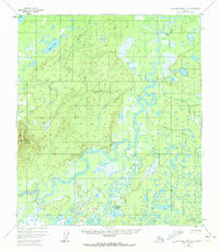
1952 Map of Kantishna River A-2
USGS Topo · Published 1972About this map
Kantishna River meanders through this interior Alaska landscape, joined by the Bearpaw River in a complex network of waterways and wetlands. Surveyed in the early 1950s, the map documents a territory defined by seasonal accessibility, centered on the Sled Road that provides a primary overland corridor through the brush. To the west, Bearpaw Mountain rises above the lowlands, while the small settlement at Bearpaw Cabins sits along the riverbank, representing a rare point of human habitation in this wilderness. Numerous water bodies like Mucha Lake, Alma Lakes, and Folger Slough dominate the eastern and southern portions of the quadrangle. The intricate drainage patterns of Chitsia Creek and Lynx Creek illustrate the saturated nature of the terrain, which remained largely unchanged during the minor revisions of the early 1970s.
Find a feature on this map
10 named features on this map. Tap any name to fly to it.
Don’t see what you’re looking for? This feature index may not catch every label — zoom into the map to look around manually.
Map Details
Editions of this 1952 Kantishna River A-2 Map
4 editions found
Other maps of this area

1948 · Kantishna River
USGS Topo · 1:250,000

1951 · Kantishna River
USGS Topo · 1:250,000

1951 · Mount McKinley D-1
USGS Topo · 1:63,360

1952 · Mount McKinley
USGS Topo · 1:250,000

1952 · Kantishna River A-3
USGS Topo · 1:63,360

1952 · Kantishna River A-1
USGS Topo · 1:63,360

1952 · Kantishna River
USGS Topo · 1:250,000

1952 · Kantishna River A-2
USGS Topo · 1:63,360

1952 · Kantishna River B-1
USGS Topo · 1:63,360

1952 · Mount McKinley D-3
USGS Topo · 1:63,360