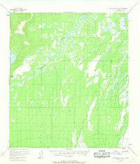
1952 Map of Mount McKinley D-3
USGS Topo · Published 1968About this map
The Kantishna River meanders through this interior Alaska landscape, forming a complex network of oxbows and wetlands characteristic of the region's wilderness during the mid-century. Based on 1952 aerial photography with revisions in 1967, the map documents a terrain largely shaped by water, from the expansive Chilchukabena Lake on the western edge to the northern flow of Bear Creek and Moose Creek. A notable human element in this remote environment is the Sled Road, which cuts across the central wetlands. This trail represents a vital link for winter transport in an era when seasonal trails were often the only reliable overland routes through the marshy lowland tundra. The map's detail provides a clear view of the drainage patterns and elevation changes before more modern development reached this part of the territory.
Find a feature on this map
5 named features on this map. Tap any name to fly to it.
Don’t see what you’re looking for? This feature index may not catch every label — zoom into the map to look around manually.
Map Details
Editions of this 1952 Mount McKinley D-3 Map
3 editions found
Other maps of this area

1948 · Kantishna River
USGS Topo · 1:250,000

1951 · Kantishna River
USGS Topo · 1:250,000

1952 · Mount McKinley
USGS Topo · 1:250,000

1952 · Kantishna River A-3
USGS Topo · 1:63,360

1952 · Kantishna River
USGS Topo · 1:250,000

1952 · Mount McKinley C-3
USGS Topo · 1:63,360

1952 · Kantishna River A-2
USGS Topo · 1:63,360

1952 · Mount McKinley C-2
USGS Topo · 1:63,360

1952 · Mount McKinley D-3
USGS Topo · 1:63,360

1953 · Kantishna River A-4
USGS Topo · 1:63,360