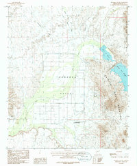
1986 Map of Dendora Valley
USGS Topo · Published 1986About this map
Painted Rocks State Historic Park anchors the southern portion of this landscape, preserving significant petroglyphs and archaeological history along the Gila River. In the mid-1980s, the terrain shows a mix of desert water management and agricultural infrastructure, with the Painted Rock Reservoir and Borrow Pit Reservoir dominating the eastern edge. The Dendora Valley floor is marked by a network of ranching and utility features, including a Feedlot, Corral, and a Landing Strip. To the north and west, the arid basin is carved by several drainages such as Loudermilk Wash and Medicine Wash. The surrounding Gila Bend Mountains and Painted Rock Mountains show evidence of mineral exploration, with numerous Prospects and a Mine Shaft located near the reservoir's western slopes.
Find a feature on this map
22 named features on this map. Tap any name to fly to it.
Don’t see what you’re looking for? This feature index may not catch every label — zoom into the map to look around manually.
Map Details
Editions of this 1986 Dendora Valley Map
This is the sole edition of this map. No revisions or reprints were ever made.
Other maps of this area

1942 · Vicksburg
USGS Topo · 1:250,000

1949 · Sentinel
USGS Topo · 1:62,500

1950 · Sentinel
USGS Topo · 1:62,500

1950 · Theba
USGS Topo · 1:62,500

1951 · Theba
USGS Topo · 1:62,500

1951 · Dendora Valley
USGS Topo · 1:62,500

1951 · Woolsey Peak
USGS Topo · 1:62,500

1953 · Ajo
USGS Topo · 1:250,000

1954 · Phoenix
USGS Topo · 1:250,000

1957 · Ajo
USGS Topo · 1:250,000