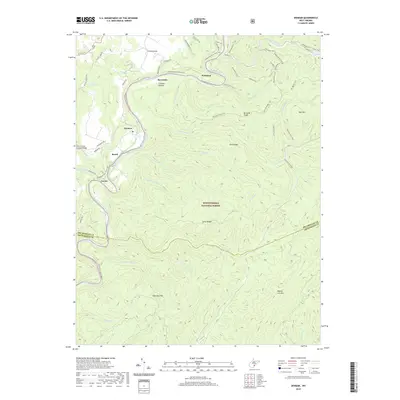
2019 Map of Denmar
USGS Topo · Published 2019About this map
The Greenbrier River carves a deep valley through the high country of West Virginia, serving as the primary corridor for settlement and transportation in this portion of the Monongahela National Forest. Small hamlets like Denmar, Beard, and Locust are clustered along the riverbanks, where the valley floor widens enough to support local communities. This modern survey shows the evolution of the regional economy from industry to recreation, evidenced by the transformation of the old rail line into the Greenbrier River Rail-Trail. Landmarks such as the Locust Creek Covered Bridge near Locust Creek highlight the preservation of the area's rural heritage. East of the river, the landscape rises sharply into a series of massive ridges including Pond Ridge and Burnside Ridge, eventually reaching the peaks of Slabcamp Mtn and Beaver Lick Mtn. This terrain is crisscrossed by an extensive network of footpaths, including the Ann Bailey Trail and Jesse's Cove Trail, which navigate the steep drainage basins of Spice Run and Oldham Run.
Find a feature on this map
63 named features on this map. Tap any name to fly to it.
Don’t see what you’re looking for? This feature index may not catch every label — zoom into the map to look around manually.
Map Details
Editions of this 2019 Denmar Map
This is the sole edition of this map. No revisions or reprints were ever made.
Other maps of this area

1887 · Lewisburg
USGS Topo · 1:125,000

1891 · Lewisburg
USGS Topo · 1:125,000

1891 · Huntersville
USGS Topo · 1:125,000

1894 · Huntersville
USGS Topo · 1:125,000

1921 · Callaghan
USGS Topo · 1:48,000

1921 · White Sulphur Springs
USGS Topo · 1:48,000

1923 · Lobelia
USGS Topo · 1:48,000

1923 · White Sulphur Springs
USGS Topo · 1:62,500

1923 · Marlinton
USGS Topo · 1:48,000

1923 · Callaghan
USGS Topo · 1:62,500