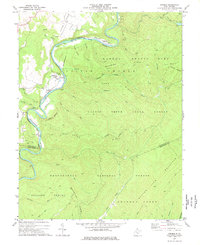
1977 Map of Denmar
USGS Topo · Published 1978About this map
The Greenbrier River carves a deep, winding path through this portion of Pocahontas County, dictating the development of the river-valley settlements and the Chesapeake and Ohio railroad line. Near a sharp bend in the river, the settlement of Denmar is distinguished by the State Hospital, accompanied by infrastructure such as Water Tanks and Sewage Disposal. This landscape is heavily defined by public lands, with the Watoga State Park and Calvin Price State Forest occupying the high ground of Oldham Ridge and Spice Ridge. Local history is anchored by sites like the Old Droop Ch and its adjacent Cem, while smaller communities such as Burnsides, Beard, and Kincaid mark the transition from river bottoms to the steep slopes of the Monongahela National Forest. The map also traces recreation and utility routes, including the Arrowhead Trail and a Lookout Tower on Burnside Ridge.
Find a feature on this map
53 named features on this map. Tap any name to fly to it.
Don’t see what you’re looking for? This feature index may not catch every label — zoom into the map to look around manually.
Map Details
Editions of this 1977 Denmar Map
2 editions found
Other maps of this area

1887 · Lewisburg
USGS Topo · 1:125,000

1891 · Lewisburg
USGS Topo · 1:125,000

1891 · Huntersville
USGS Topo · 1:125,000

1894 · Huntersville
USGS Topo · 1:125,000

1921 · Callaghan
USGS Topo · 1:48,000

1921 · White Sulphur Springs
USGS Topo · 1:48,000

1923 · Lobelia
USGS Topo · 1:48,000

1923 · White Sulphur Springs
USGS Topo · 1:62,500

1923 · Marlinton
USGS Topo · 1:48,000

1923 · Callaghan
USGS Topo · 1:62,500