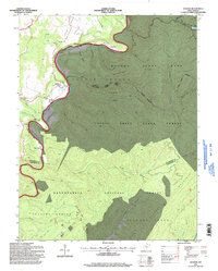
1995 Map of Denmar
USGS Topo · Published 1998About this map
The Greenbrier River carves a deep valley through this pocket of the Allegheny Mountains, serving as the primary corridor for small settlements like Beard and Locust. On the eastern bank, the massive Denmar State Hospital stands as a prominent landmark near the river's edge, supported by infrastructure including Water Tanks and a dedicated sewage system. This map illustrates a landscape heavily defined by public land management, where the boundaries of the Monongahela National Forest, Watoga State Park, and Calvin Price State Forest converge. For those interested in local heritage, the map identifies Old Droop Ch and various cemeteries, alongside several rail-trail precursors like the Arrowhead Trail and the Bridle Path winding through the timbered slopes of Stabcamp Mtn.
Find a feature on this map
54 named features on this map. Tap any name to fly to it.
Don’t see what you’re looking for? This feature index may not catch every label — zoom into the map to look around manually.
Map Details
Editions of this 1995 Denmar Map
This is the sole edition of this map. No revisions or reprints were ever made.
Other maps of this area

1887 · Lewisburg
USGS Topo · 1:125,000

1891 · Lewisburg
USGS Topo · 1:125,000

1891 · Huntersville
USGS Topo · 1:125,000

1894 · Huntersville
USGS Topo · 1:125,000

1921 · Callaghan
USGS Topo · 1:48,000

1921 · White Sulphur Springs
USGS Topo · 1:48,000

1923 · Lobelia
USGS Topo · 1:48,000

1923 · White Sulphur Springs
USGS Topo · 1:62,500

1923 · Marlinton
USGS Topo · 1:48,000

1923 · Callaghan
USGS Topo · 1:62,500