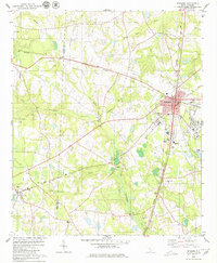
1979 Map of Denmark
USGS Topo · Published 1980About this map
Denmark serves as a critical junction in the late 1970s, where the Southern and Seaboard Coast Line railroads intersect in the heart of Bamberg County. This transportation hub is mirrored by its educational significance, featuring Voorhees College, the Vocational Sch, and the Denmark-Olar High Sch. The surrounding rural landscape is defined by the Little Salkehatchie River and its numerous tributaries like Ghents Branch and Hollymood Branch, which carve through the Lowcountry terrain. The distribution of small rural communities such as Lees, Hilda, and Blackville indicates a post-war pattern of dispersed agricultural settlements connected by a maturing road network.
Find a feature on this map
36 named features on this map. Tap any name to fly to it.
Don’t see what you’re looking for? This feature index may not catch every label — zoom into the map to look around manually.
Map Details
Editions of this 1979 Denmark Map
2 editions found
Other maps of this area

1919 · Olar
USGS Topo · 1:62,500

1919 · Bamberg
USGS Topo · 1:48,000

1919 · Allendale
USGS Topo · 1:62,500

1920 · Bamberg
USGS Topo · 1:62,500

1923 · Williston
USGS Topo · 1:48,000

1927 · Williston
USGS Topo · 1:62,500

1943 · Olar
USGS Topo · 1:62,500

1943 · Allendale
USGS Topo · 1:62,500

1943 · Bamberg
USGS Topo · 1:62,500

1943 · Williston
USGS Topo · 1:62,500