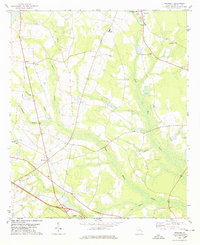
1978 Map of Denmark
USGS Topo · Published 1978About this map
Brooklet and the surrounding rural landscape of Bulloch County are defined by a network of agricultural settlements and slow-moving waterways in this late-1970s survey. The terrain is structured by the winding courses of Lower Black Creek and Upper Black Creek, which converge amidst the broad wetlands of Luke Swamp Creek. This area shows a dense distribution of community life centered on rural institutions, including Emit Grove Ch and Little Bethel Ch. Educational landmarks such as Southeast Bulloch High Sch and High Hope Sch anchor the local geography. The settlement at Denmark serves as a central point for numerous family-named landmarks and smaller hamlets like Emit and Truckers, providing a detailed look at the rural road network and township development before modern suburban expansion significantly altered the coastal plain landscape.
Find a feature on this map
25 named features on this map. Tap any name to fly to it.
Don’t see what you’re looking for? This feature index may not catch every label — zoom into the map to look around manually.
Map Details
Editions of this 1978 Denmark Map
This is the sole edition of this map. No revisions or reprints were ever made.
Other maps of this area

1919 · Claxton
USGS Topo · 1:62,500

1920 · Pembroke
USGS Topo · 1:62,500

1920 · Statesboro
USGS Topo · 1:62,500

1921 · Brooklet
USGS Topo · 1:62,500

1943 · Brooklet
USGS Topo · 1:62,500

1943 · Statesboro
USGS Topo · 1:62,500

1944 · Claxton
USGS Topo · 1:62,500

1947 · Savannah
USGS Topo · 1:250,000

1948 · Savannah
USGS Topo · 1:250,000

1948 · Pembroke
USGS Topo · 1:62,500