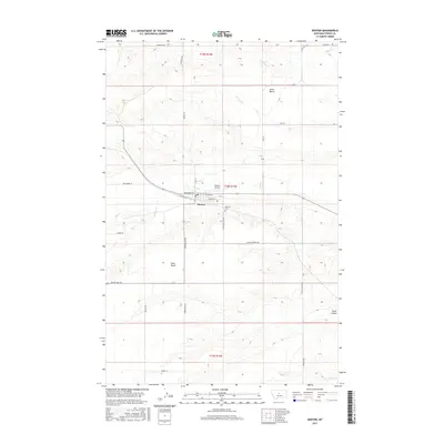
2017 Map of Denton
USGS Topo · Published 2017About this map
Denton serves as the central hub for this portion of Fergus County, situated at the junction of Elevator Rd and several primary thoroughfares like Broadway St and Hwy Main St. The landscape is defined by its distinct agricultural benches, including Alton Bench to the north and Iowa Bench to the south, which overlook a complex network of seasonal and perennial waterways. Wolf Cr and Coyote Cr wind through the township, cutting through the elevation changes that characterize this high plains region. Evidence of the local aviation and civic infrastructure is present in the Denton Airport and Hillcrest Cem, while the outer reaches of the quadrangle reveal the transition into more broken terrain at Pacer Coulee. The mapping of townships t18n r14e, t19n r14e, and t17n r14e shows a meticulous grid of rural roads, such as Benchland Rd and Hoosac Rd, that support the region's ranching and farming operations.
Find a feature on this map
33 named features on this map. Tap any name to fly to it.
Don’t see what you’re looking for? This feature index may not catch every label — zoom into the map to look around manually.
Map Details
Editions of this 2017 Denton Map
This is the sole edition of this map. No revisions or reprints were ever made.
Other maps of this area

1890 · Fort Benton
USGS Topo · 1:250,000

1892 · Fort Benton
USGS Topo · 1:250,000

1897 · Fort Benton
USGS Topo · 1:250,000

1954 · Great Falls
USGS Topo · 1:250,000

1954 · Lewistown
USGS Topo · 1:250,000

1957 · Great Falls
USGS Topo · 1:250,000

1959 · Lewistown
USGS Topo · 1:250,000

1970 · Harwood Bench
USGS Topo · 1:24,000
1970 · Big Spring
USGS Topo · 1:24,000
1978 · Stanford NE
USGS Topo · 1:24,000