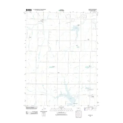
2011 Map of Denton
USGS Topo · Published 2011About this map
The village of Denton sits at the northern edge of this 2011 survey, a small rural hub in Lancaster County defined by its relationship to the shifting prairie waterways and drainage basins. This area south of Lincoln is characterized by an extensive network of flood control structures and recreational waters, including the sprawling Bluestem Lake and Yankee Hill Lake. These reservoirs are fed by a complex system of creeks like Haines Branch, Cardwell Branch, and Wirtstruck Creek, which carve through the grid of section roads.
Find a feature on this map
51 named features on this map. Tap any name to fly to it.
Don’t see what you’re looking for? This feature index may not catch every label — zoom into the map to look around manually.
Map Details
Editions of this 2011 Denton Map
This is the sole edition of this map. No revisions or reprints were ever made.
Other maps of this area

1897 · Lincoln
USGS Topo · 1:125,000

1955 · Lincoln
USGS Topo · 1:250,000

1957 · Lincoln
USGS Topo · 1:250,000

1958 · Lincoln
USGS Topo · 1:250,000

1964 · Cortland
USGS Topo · 1:24,000
1964 · Hallam
USGS Topo · 1:24,000
1964 · Crete South
USGS Topo · 1:24,000
1964 · Crete North
USGS Topo · 1:24,000

1964 · Denton
USGS Topo · 1:24,000

1964 · Roca
USGS Topo · 1:24,000