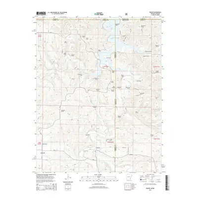
2014 Map of Denver
USGS Topo · Published 2014About this map
Denver serves as a central point of interest in this Ozark borderland, where the winding waters of Table Rock Lake reach south into Arkansas from the Missouri state line. The landscape is defined by a dense network of hollows and bluffs, including Davis Bluff and Raven Bluff, which overlook the complex drainage patterns of Long Creek and Cricket Cr. Historically significant sites for family researchers include Denver Cem and Enon Cem, situated among family-named landmarks like Kimhowart Hill and Fortner Hollow. The map reveals the modern rural character of the area, where established settlements like Farewell are connected by a web of county roads and state highways such as Ar-311. The topography here is intricate, with numerous small spring-fed branches and creeks like Stillhouse Cr and Spring Cr carving out deep terrain features such as Gum Spring Hollow and Tereherst Hollow.
Find a feature on this map
92 named features on this map. Tap any name to fly to it.
Don’t see what you’re looking for? This feature index may not catch every label — zoom into the map to look around manually.
Map Details
Editions of this 2014 Denver Map
This is the sole edition of this map. No revisions or reprints were ever made.
Other maps of this area

1904 · Harrison
USGS Topo · 1:125,000

1905 · Harrison
USGS Topo · 1:125,000

1907 · Forsyth
USGS Topo · 1:125,000

1945 · Harrison
USGS Topo · 1:250,000

1949 · Harrison
USGS Topo · 1:250,000

1954 · Harrison
USGS Topo · 1:250,000

1956 · Lampe
USGS Topo · 1:24,000

1956 · Table Rock Dam
USGS Topo · 1:24,000
1956 · Hollister
USGS Topo · 1:24,000

1958 · Harrison
USGS Topo · 1:250,000