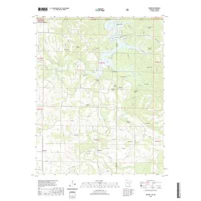
2020 Map of Denver
USGS Topo · Published 2020About this map
Denver and Farewell anchor this rural landscape along the Arkansas-Missouri border, where the terrain is defined by a dense network of hollows and ridges draining toward Table Rock Lake. The map illustrates a region of deep family roots and small-town continuity, marked by significant sites like Denver Cem and Enon Cem. To the northwest, the Mark Twain National Forest establishes a preserved wilderness boundary, while the central topography is carved by Yocum Cr and Long Creek. The naming of prominent landmarks like Backbone Bluff, Raven Bluff, and Kimhowart Hill reflects the long-standing local identification with the physical geography. Tracing the numerous creek branches such as Callens Br and Stillhouse Cr provides insight into the historic drainage patterns and land use in this section of Carroll and Boone Counties.
Find a feature on this map
96 named features on this map. Tap any name to fly to it.
Don’t see what you’re looking for? This feature index may not catch every label — zoom into the map to look around manually.
Map Details
Editions of this 2020 Denver Map
This is the sole edition of this map. No revisions or reprints were ever made.
Other maps of this area

1904 · Harrison
USGS Topo · 1:125,000

1905 · Harrison
USGS Topo · 1:125,000

1907 · Forsyth
USGS Topo · 1:125,000

1945 · Harrison
USGS Topo · 1:250,000

1949 · Harrison
USGS Topo · 1:250,000

1954 · Harrison
USGS Topo · 1:250,000

1956 · Lampe
USGS Topo · 1:24,000

1956 · Table Rock Dam
USGS Topo · 1:24,000
1956 · Hollister
USGS Topo · 1:24,000

1958 · Harrison
USGS Topo · 1:250,000