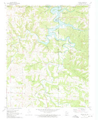
1972 Map of Denver
USGS Topo · Published 1973About this map
Denver serves as a central landmark in this 1970s topographical survey of northern Arkansas and southern Missouri. The landscape is defined by the winding waters of Table Rock Lake, which follows the deep incisions of Long Creek and its various tributaries. This era of the Ozarks transition is characterized by a mix of agricultural clearings and forested ridges, including portions of the Mark Twain Nat Forest near the border. Local history is preserved through scattered burial grounds like Denver Cem and Enon Cem, while the rugged relief is illustrated by prominent features such as Backbone Bluff and Kimhowart Hill. The network of hollows—including Bear Hollow, Fortner Hollow, and Cove Hollow—underscores the complex drainage patterns that lead into the reservoir, reflecting a period when recreational development at the Cricket Creek Public Use Area sat alongside established rural communities.
Find a feature on this map
45 named features on this map. Tap any name to fly to it.
Don’t see what you’re looking for? This feature index may not catch every label — zoom into the map to look around manually.
Map Details
Editions of this 1972 Denver Map
This is the sole edition of this map. No revisions or reprints were ever made.
Other maps of this area

1904 · Harrison
USGS Topo · 1:125,000

1905 · Harrison
USGS Topo · 1:125,000

1907 · Forsyth
USGS Topo · 1:125,000

1945 · Harrison
USGS Topo · 1:250,000

1949 · Harrison
USGS Topo · 1:250,000

1954 · Harrison
USGS Topo · 1:250,000

1956 · Lampe
USGS Topo · 1:24,000

1956 · Table Rock Dam
USGS Topo · 1:24,000
1956 · Hollister
USGS Topo · 1:24,000

1958 · Harrison
USGS Topo · 1:250,000