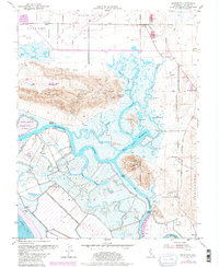
1980 Map of Denverton
USGS Topo · Published 1987About this map
The Montezuma Slough and its intricate network of winding waterways dominate this landscape at the northern edge of Grizzly Bay. The 1980 revisions reveal a complex estuarine environment where Grizzly Island and Joice Island are defined by tidal channels like Nurse Slough and Frost Slough. This region serves as a critical junction for water management and wildlife, noted by the presence of the Joice Island State Game Refuge and the State Fish and Game Headquarters.
Find a feature on this map
45 named features on this map. Tap any name to fly to it.
Don’t see what you’re looking for? This feature index may not catch every label — zoom into the map to look around manually.
Map Details
Editions of this 1980 Denverton Map
This is the sole edition of this map. No revisions or reprints were ever made.
Other maps of this area

1896 · Carquinez Strait
USGS Topo · 1:62,500

1898 · Karquines
USGS Topo · 1:62,500

1901 · Karquines
USGS Topo · 1:62,500

1902 · Napa
USGS Topo · 1:125,000

1907 · Antioch
USGS Topo · 1:62,500

1908 · Vacaville
USGS Topo · 1:62,500

1908 · Antioch
USGS Topo · 1:62,500

1916 · Maine Prairie
USGS Topo · 1:31,680

1917 · Elmira
USGS Topo · 1:31,680

1918 · Honker Bay
USGS Topo · 1:31,680