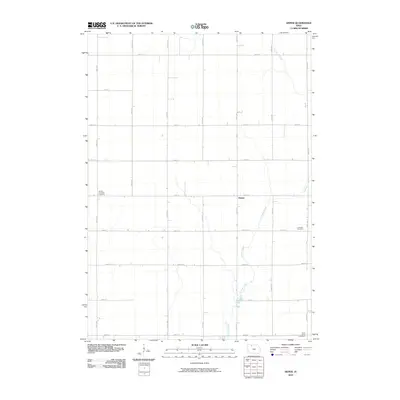
2010 Map of Depew
USGS Topo · Published 2010About this map
Depew serves as the central hub of this agricultural landscape in Palo Alto County, where the rigid section-line road network of the Iowa plains is defined by routes like 530th Ave and 320th St. The terrain is subtly shaped by the winding course of Cylinder Creek, which meanders from the northwest toward the southeast, providing a natural break in the geometric grid of farm plots. For those researching local heritage, the map identifies several significant burial sites that mark the community's history, including the Vernon Township Cemetery in the west, the Lutheran Cemetery to the east, and Saint Johns Cemetery at the southern boundary. These features reflect the long-standing church and township foundations that have anchored this rural area through the early 21st century.
Find a feature on this map
21 named features on this map. Tap any name to fly to it.
Don’t see what you’re looking for? This feature index may not catch every label — zoom into the map to look around manually.
Map Details
Editions of this 2010 Depew Map
This is the sole edition of this map. No revisions or reprints were ever made.
Other maps of this area

1954 · Fairmont
USGS Topo · 1:250,000

1958 · Fairmont
USGS Topo · 1:250,000

1980 · Fenton
USGS Topo · 1:24,000

1980 · Depew
USGS Topo · 1:24,000

1980 · Seneca
USGS Topo · 1:24,000

1980 · Ringsted
USGS Topo · 1:24,000

1980 · Ingham Lake
USGS Topo · 1:24,000

1980 · Graettinger East
USGS Topo · 1:24,000
1980 · Emmetsburg
USGS Topo · 1:24,000
1980 · Whittemore
USGS Topo · 1:24,000