
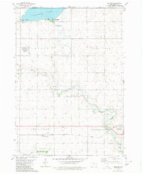
1980 Map of Ingham Lake
USGS Topo · Published 1980About this map
Swan Lake and the surrounding glacial basins of Emmet County define this landscape as it appeared in the late 1970s. The area is dominated by extensive conservation efforts, including the West Swan Lake State Game Management Area and the Ingham Lake State Game Management Area, which protect the complex of sloughs and water bodies such as North Slough and Cunningham Slough. Genealogists and local historians can locate the Swan Lake Village Cem near the north shore of the lake and the High Lake Cem to the south. Transport history is marked by an Old Railroad Grade cutting through the southwest corner near the Des Moines River, while rural community life is anchored by landmarks like Immanuel Ch and the recreational grounds of Wolden County Park.
Find a feature on this map
29 named features on this map. Tap any name to fly to it.
Don’t see what you’re looking for? This feature index may not catch every label — zoom into the map to look around manually.
Map Details
Editions of this 1980 Ingham Lake Map
This is the sole edition of this map. No revisions or reprints were ever made.
Other maps of this area

1954 · Fairmont
USGS Topo · 1:250,000

1958 · Fairmont
USGS Topo · 1:250,000

1972 · Graettinger West
USGS Topo · 1:24,000

1972 · Wallingford
USGS Topo · 1:24,000

1972 · Estherville
USGS Topo · 1:24,000

1980 · Depew
USGS Topo · 1:24,000

1980 · Ringsted
USGS Topo · 1:24,000

1980 · Gruver
USGS Topo · 1:24,000

1980 · Graettinger East
USGS Topo · 1:24,000
1980 · Dolliver
USGS Topo · 1:24,000