
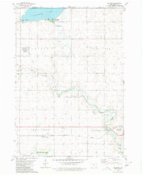
1980 Map of Gruver
USGS Topo · Published 1980About this map
Gruver serves as the primary hub of this North Central Iowa landscape, situated along the Chicago Rock Island and Pacific railroad line. The surrounding terrain in Center, Ellsworth, and Lincoln townships is defined by a sophisticated water management network including Ditch No 40 and Ditch No 7. These channels reflect the transition of prairie wetlands into productive farmland during the late 20th century. Conservation efforts are evident in the designated Birge Lake State Game Management Area and East Swan Lake State Game Management Area. Local history is preserved through scattered rural landmarks like the Palestine Ch and several family or community burial grounds, including Ellsworth Cem and Palestine Cem. On the western edge, the Estherville Municipal Airport marks the influence of modern infrastructure on this traditional agricultural region.
Find a feature on this map
24 named features on this map. Tap any name to fly to it.
Don’t see what you’re looking for? This feature index may not catch every label — zoom into the map to look around manually.
Map Details
Editions of this 1980 Gruver Map
This is the sole edition of this map. No revisions or reprints were ever made.
Other maps of this area

1954 · Fairmont
USGS Topo · 1:250,000

1958 · Fairmont
USGS Topo · 1:250,000

1970 · Ceylon
USGS Topo · 1:24,000

1970 · Dunnell
USGS Topo · 1:24,000

1970 · Wilbert
USGS Topo · 1:24,000

1972 · Wallingford
USGS Topo · 1:24,000

1972 · Estherville
USGS Topo · 1:24,000

1980 · Ringsted
USGS Topo · 1:24,000

1980 · Ingham Lake
USGS Topo · 1:24,000
1980 · Dolliver
USGS Topo · 1:24,000