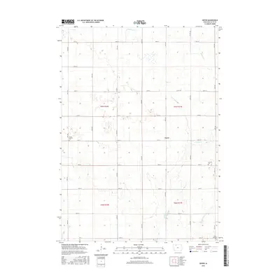
2015 Map of Depew
USGS Topo · Published 2015About this map
Depew and the surrounding agricultural landscape of Palo Alto County are defined by a complex network of managed waterways, including Ditch Number 21, Ditch Number 28, and Ditch Number 80. These man-made channels support the high-yield farming typical of this Iowa region, while Cylinder Cr follows a more meandering path through the prairie. The landscape is organized by a precise grid of roads, such as Co HWY b19 and 520th Ave, which intersect the townships of t97n r32w and t97n r31w. Local history and genealogy are anchored by several remote burial grounds, including the Vernon Township Cem to the west and the Lutheran Cem and Saint Johns Cem along the eastern margin of the quadrangle. These sites represent the early community foundations in an area characterized by scattered homesteads and vast acreage.
Find a feature on this map
32 named features on this map. Tap any name to fly to it.
Don’t see what you’re looking for? This feature index may not catch every label — zoom into the map to look around manually.
Map Details
Editions of this 2015 Depew Map
This is the sole edition of this map. No revisions or reprints were ever made.
Other maps of this area

1954 · Fairmont
USGS Topo · 1:250,000

1958 · Fairmont
USGS Topo · 1:250,000

1980 · Fenton
USGS Topo · 1:24,000

1980 · Depew
USGS Topo · 1:24,000

1980 · Seneca
USGS Topo · 1:24,000

1980 · Ringsted
USGS Topo · 1:24,000

1980 · Ingham Lake
USGS Topo · 1:24,000

1980 · Graettinger East
USGS Topo · 1:24,000
1980 · Emmetsburg
USGS Topo · 1:24,000
1980 · Whittemore
USGS Topo · 1:24,000