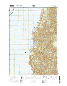
2017 Map of Depoe Bay
USGS Topo · Published 2017About this map
The central Oregon coast at Depoe Bay is defined by a series of dramatic volcanic headlands and narrow coves, where the Pacific shelf meets a complex network of coastal creeks. This 2017 survey details the residential growth north of the harbor in Lincoln Beach and Coronado Shores, contrasting with the more industrial and transit-focused infrastructure like the Siletz Bay State Airport and the historic Ben Jones Bridge spanning Rocky Cr. The landscape transitions from the jagged shoreline of Cape Foulweather and Whale Cove to the elevated terrain of Siletz Hill, where the timbered ridges of the t8s r11w and t9s r11w sections overlook the Siletz River valley. Inland, water management is evident at the N Depoe Bay Reservoir, supporting the settlement patterns that have developed along the rugged littoral edge of the Pacific Ocean.
Find a feature on this map
48 named features on this map. Tap any name to fly to it.
Don’t see what you’re looking for? This feature index may not catch every label — zoom into the map to look around manually.
Map Details
Editions of this 2017 Depoe Bay Map
This is the sole edition of this map. No revisions or reprints were ever made.
Other maps of this area

1941 · Cape Foulweather
USGS Topo · 1:62,500

1942 · Euchre Mtn
USGS Topo · 1:62,500

1942 · Yaquina
USGS Topo · 1:62,500

1942 · Toledo
USGS Topo · 1:62,500

1943 · Euchre Mtn
USGS Topo · 1:62,500

1944 · Cape Foulweather
USGS Topo · 1:62,500

1953 · Salem
USGS Topo · 1:250,000

1954 · Salem
USGS Topo · 1:250,000

1957 · Cape Foulweather
USGS Topo · 1:62,500

1957 · Yaquina
USGS Topo · 1:62,500