
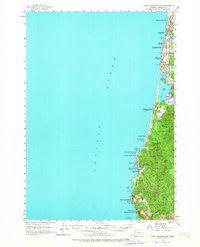
1957 Map of Cape Foulweather
USGS Topo · Published 1958About this map
The Oregon Coast Highway dictates the rhythm of settlement along this coastal stretch of Lincoln County, linking a series of distinct seaside communities. These towns, including Wecoma Beach, Oceanlake, and Nelscott, are concentrated on the narrow terrace between the Pacific Ocean and the coastal range. At Delake, the tiny D River connects the freshwater Devils Lake to the sea, a unique geographic feature that has long defined the local identity. Farther south, the landscape becomes more dramatic where the Siletz River feeds into Siletz Bay near Kernville. The survey captures the early development of Depoe Bay and its notably small natural harbor. Public land preservation is already a priority here, with numerous small parcels designated as state parks, such as Boiler Bay State Park and Fogarty Creek State Park, protecting the rocky headlands from development.
Find a feature on this map
37 named features on this map. Tap any name to fly to it.
Don’t see what you’re looking for? This feature index may not catch every label — zoom into the map to look around manually.
Map Details
Editions of this 1957 Cape Foulweather Map
2 editions found
Other maps of this area

1941 · Nestucca Bay
USGS Topo · 1:62,500

1941 · Cape Foulweather
USGS Topo · 1:62,500

1942 · Euchre Mtn
USGS Topo · 1:62,500

1942 · Nestucca Bay
USGS Topo · 1:62,500

1942 · Yaquina
USGS Topo · 1:62,500

1942 · Toledo
USGS Topo · 1:62,500

1943 · Euchre Mtn
USGS Topo · 1:62,500

1944 · Cape Foulweather
USGS Topo · 1:62,500

1948 · Vancouver
USGS Topo · 1:250,000

1950 · Vancouver
USGS Topo · 1:250,000