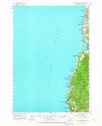
1957 Map of Cape Foulweather
USGS Topo · Published 1967About this map
Lincoln City serves as the focal point of this coastal survey, where a string of beach communities such as Wecoma Beach, Oceanlake, and Delake line the shore of the Pacific Ocean. This period reflects the consolidation of these local settlements, while the interior remains defined by the winding course of the Siletz River and Schooner Creek. The landscape transitions from the sandy stretches near Devils Lake to the prominent headlands at Cape Foulweather and Otter Crest. Along the Oregon Coast Highway, a series of protected lands like Boiler Bay State Park and Rocky Creek State Park suggest an early emphasis on public access to the shoreline. Small-scale industrial activity is represented by a Gravel Pit near the southern coast, while the local education system is anchored by the High School in Taft.
Find a feature on this map
43 named features on this map. Tap any name to fly to it.
Don’t see what you’re looking for? This feature index may not catch every label — zoom into the map to look around manually.
Map Details
Editions of this 1957 Cape Foulweather Map
2 editions found

Other maps of this area

1941 · Nestucca Bay
USGS Topo · 1:62,500

1941 · Cape Foulweather
USGS Topo · 1:62,500

1942 · Euchre Mtn
USGS Topo · 1:62,500

1942 · Nestucca Bay
USGS Topo · 1:62,500

1942 · Yaquina
USGS Topo · 1:62,500

1942 · Toledo
USGS Topo · 1:62,500

1943 · Euchre Mtn
USGS Topo · 1:62,500

1944 · Cape Foulweather
USGS Topo · 1:62,500

1948 · Vancouver
USGS Topo · 1:250,000

1950 · Vancouver
USGS Topo · 1:250,000