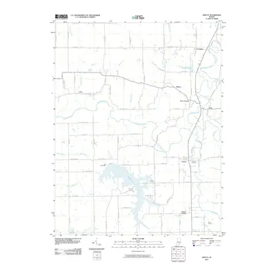
2010 Map of Deputy
USGS Topo · Published 2010About this map
Hardy Lake and its surrounding wetlands dominate the southern landscape of this Jennings County survey. The Muscatatuck River winds through the central terrain, carving a path between the settlements of Paris Crossing and Hilltown. This 2010 map records a region defined by its water systems and rural crossroads, where small communities like Deputy and Commiskey sit amidst a network of county roads such as S Co Rd 750 W. For those researching family history, several burial sites are documented including Keith Cemetery near Slate Creek, Robertson Cemetery, and Valley Cemetery to the southeast. The map also captures infrastructure details like the Lake Hardy Dam and the small whistle-stop location at Parkers Station, providing a comprehensive look at the modern rural layout of this Indiana territory.
Find a feature on this map
79 named features on this map. Tap any name to fly to it.
Don’t see what you’re looking for? This feature index may not catch every label — zoom into the map to look around manually.
Map Details
Editions of this 2010 Deputy Map
This is the sole edition of this map. No revisions or reprints were ever made.
Other maps of this area

1947 · Scottsburg
USGS Topo · 1:24,000

1956 · Volga
USGS Topo · 1:24,000

1956 · Blocher
USGS Topo · 1:24,000

1956 · Kent
USGS Topo · 1:24,000

1956 · Deputy
USGS Topo · 1:24,000

1956 · Louisville
USGS Topo · 1:250,000
1959 · Vernon
USGS Topo · 1:24,000
1959 · Hayden
USGS Topo · 1:24,000

1959 · Crothersville
USGS Topo · 1:24,000
1959 · Chestnut Ridge
USGS Topo · 1:24,000