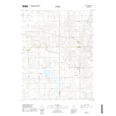
2019 Map of Deputy
USGS Topo · Published 2019About this map
The Muscatatuck River winds through this southern Indiana landscape, marking a winding natural boundary where Jennings, Scott, and Jefferson counties converge. This modern survey illustrates a rural region centered on the historic railroad settlement of Deputy and the neighboring community of Paris Crossing. The CSX Transportation line remains a defining industrial feature, running north-south through Commiskey and past several family-named landmarks. Genealogists and local historians can locate several burial sites throughout the townships, including Robertson Cem near Deputy and Keith Cem to the west. The terrain is defined by a dense network of tributaries like Graham Creek and Coffee Cr, while recreational paths such as the Island Trail and Outward Bound Trail suggest the area's transition towards conservation and outdoor use.
Find a feature on this map
104 named features on this map. Tap any name to fly to it.
Don’t see what you’re looking for? This feature index may not catch every label — zoom into the map to look around manually.
Map Details
Editions of this 2019 Deputy Map
This is the sole edition of this map. No revisions or reprints were ever made.
Other maps of this area

1947 · Scottsburg
USGS Topo · 1:24,000

1956 · Volga
USGS Topo · 1:24,000

1956 · Blocher
USGS Topo · 1:24,000

1956 · Kent
USGS Topo · 1:24,000

1956 · Deputy
USGS Topo · 1:24,000

1956 · Louisville
USGS Topo · 1:250,000
1959 · Vernon
USGS Topo · 1:24,000
1959 · Hayden
USGS Topo · 1:24,000

1959 · Crothersville
USGS Topo · 1:24,000
1959 · Chestnut Ridge
USGS Topo · 1:24,000