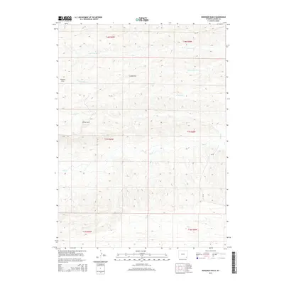
2015 Map of Dereemer Ranch
USGS Topo · Published 2015About this map
Dereemer Ranch sits at the heart of this Laramie County landscape, representing the enduring ranching traditions of southeastern Wyoming. The terrain is defined by a complex network of seasonal and perennial waterways, including the winding Horse Cr and the branching systems of N Br Little Bear Cr and S Fork Little Bear Cr. These water sources are flanked by prominent geographical features like Sheppard Draw and Gundby Draw, which illustrate the natural drainage patterns of the high plains. A sparse network of rural routes, such as True Rd, Cr-229, and Cr-228, provides the primary access through these vast sections of the Public Land Survey System. The map documents a quiet, high-elevation agricultural region where the placement of water and topography dictates the layout of human settlement.
Find a feature on this map
17 named features on this map. Tap any name to fly to it.
Don’t see what you’re looking for? This feature index may not catch every label — zoom into the map to look around manually.
Map Details
Editions of this 2015 Dereemer Ranch Map
This is the sole edition of this map. No revisions or reprints were ever made.
Other maps of this area

1905 · Sherman
USGS Topo · 1:125,000

1911 · Cheyenne
USGS Topo · 1:125,000

1914 · Cheyenne
USGS Topo · 1:125,000

1954 · Cheyenne
USGS Topo · 1:250,000

1958 · Cheyenne
USGS Topo · 1:250,000

1962 · Horse Creek
USGS Topo · 1:24,000

1962 · Federal
USGS Topo · 1:24,000

1962 · Dereemer Ranch
USGS Topo · 1:24,000

1962 · Farthing
USGS Topo · 1:24,000
1962 · Farthing Ranch
USGS Topo · 1:24,000