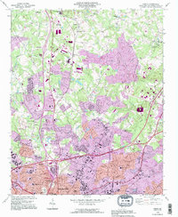
1993 Map of Derita
USGS Topo · Published 1996About this map
The Derita Mineral Spring and the Metrolina Fairgrounds highlight the suburban expansion of northern Charlotte as it appeared during the late twentieth century. This survey documents the intersection of legacy rural institutions and rapid urban development, with older landmarks like the Sugar Creek Burying Ground and Mallard Creek Community House standing alongside newer infrastructure. The landscape is defined by the Norfolk Southern rail line and a complex network of interstate interchanges that fueled the growth of neighborhoods like Lincoln Heights and Junker.
Find a feature on this map
87 named features on this map. Tap any name to fly to it.
Don’t see what you’re looking for? This feature index may not catch every label — zoom into the map to look around manually.
Map Details
Editions of this 1993 Derita Map
This is the sole edition of this map. No revisions or reprints were ever made.
Other maps of this area

1905 · Charlotte
USGS Topo · 1:48,000

1907 · Charlotte
USGS Topo · 1:62,500

1941 · Charlotte
USGS Topo · 1:125,000

1942 · Charlotte
USGS Topo · 1:125,000

1948 · Paw Creek
USGS Topo · 1:24,000

1948 · Derita
USGS Topo · 1:24,000

1948 · Charlotte East
USGS Topo · 1:24,000

1948 · Charlotte West
USGS Topo · 1:24,000

1949 · Kannapolis
USGS Topo · 1:24,000

1949 · Charlotte West
USGS Topo · 1:24,000