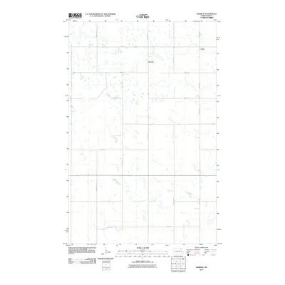
2011 Map of Derrick
USGS Topo · Published 2011About this map
Derrick sits at the heart of this Ramsey County landscape, characterized by a dense network of small seasonal wetlands and prairie potholes typical of the region. This 2011 survey illustrates the rural township structure defined by a strict grid of gravel and section roads, including 74th St NE and 99th Ave NE. The most significant landmark for local history and genealogy is Prospect Cemetery, located in the northeastern portion of the quadrangle near the intersection of 73rd St NE. The map provides a clear look at the dispersed nature of human settlement in this part of North Dakota, where the vast majority of the land is dedicated to agricultural use, dotted only by the occasional farmstead and the central point of Derrick.
Find a feature on this map
14 named features on this map. Tap any name to fly to it.
Don’t see what you’re looking for? This feature index may not catch every label — zoom into the map to look around manually.
Map Details
Editions of this 2011 Derrick Map
This is the sole edition of this map. No revisions or reprints were ever made.
Other maps of this area

1953 · Devils Lake
USGS Topo · 1:250,000

1956 · Devils Lake
USGS Topo · 1:250,000

1970 · Alsen SE
USGS Topo · 1:24,000

1970 · Hampden
USGS Topo · 1:24,000

1972 · Derrick NW
USGS Topo · 1:24,000

1972 · Derrick
USGS Topo · 1:24,000

1972 · Derrick SE
USGS Topo · 1:24,000
1972 · Derrick SW
USGS Topo · 1:24,000

1972 · Edmore SW
USGS Topo · 1:24,000

1972 · Edmore
USGS Topo · 1:24,000