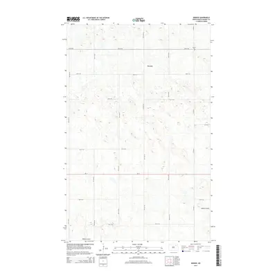
2014 Map of Derrick
USGS Topo · Published 2014About this map
Derrick centers this agricultural landscape in Ramsey County, characterized by a dense network of glacial prairie potholes and wetlands. The terrain is defined by its subtle drainage patterns, most notably Edmore Coulee, which winds through the southern section of the quadrangle. As a modern 2014 survey, it documents the persistent section-line road grid that has structured North Dakota farming for over a century, including Co Road 4 and Nd-17. For local historians and genealogists, the map identifies Prospect Cem in the northeast, a vital landmark for tracing the early families of this rural community. The township structure remains remarkably intact, with primary travel corridors like 74th St NE and 97th Ave NE providing the skeleton for the region's wheat and small-grain agricultural operations.
Find a feature on this map
17 named features on this map. Tap any name to fly to it.
Don’t see what you’re looking for? This feature index may not catch every label — zoom into the map to look around manually.
Map Details
Editions of this 2014 Derrick Map
This is the sole edition of this map. No revisions or reprints were ever made.
Other maps of this area

1953 · Devils Lake
USGS Topo · 1:250,000

1956 · Devils Lake
USGS Topo · 1:250,000

1970 · Alsen SE
USGS Topo · 1:24,000

1970 · Hampden
USGS Topo · 1:24,000

1972 · Derrick NW
USGS Topo · 1:24,000

1972 · Derrick
USGS Topo · 1:24,000

1972 · Derrick SE
USGS Topo · 1:24,000
1972 · Derrick SW
USGS Topo · 1:24,000

1972 · Edmore SW
USGS Topo · 1:24,000

1972 · Edmore
USGS Topo · 1:24,000