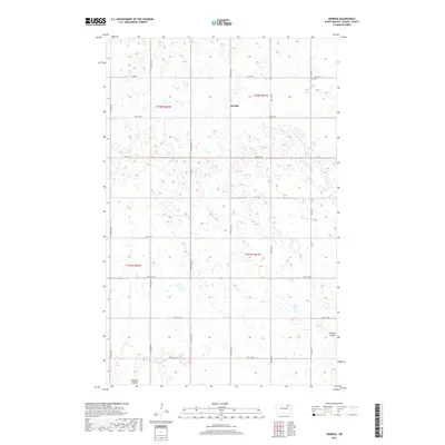
2017 Map of Derrick
USGS Topo · Published 2017About this map
Derrick sits at the center of this Ramsey County landscape, characterized by the intricate drainage patterns of the Edmore Coulee. The terrain is defined by numerous small depressions and seasonal wetlands typical of the prairie pothole region, where the land is strictly divided by the Public Land Survey System into townships like t158n r61w and t158n r62w. For those tracing local history, Prospect Cem is located in the northeastern corner of the quadrangle along CO Hwy 9, serving as a permanent landmark in an area dominated by agricultural sections and a grid of secondary roads such as 73rd St NE and 67th St NE. The map illustrates the late 20th and early 21st-century rural layout, where small settlements like Derrick persist as vital points of reference amidst the vast network of coulees and fields.
Find a feature on this map
15 named features on this map. Tap any name to fly to it.
Don’t see what you’re looking for? This feature index may not catch every label — zoom into the map to look around manually.
Map Details
Editions of this 2017 Derrick Map
This is the sole edition of this map. No revisions or reprints were ever made.
Other maps of this area

1953 · Devils Lake
USGS Topo · 1:250,000

1956 · Devils Lake
USGS Topo · 1:250,000

1970 · Alsen SE
USGS Topo · 1:24,000

1970 · Hampden
USGS Topo · 1:24,000

1972 · Derrick NW
USGS Topo · 1:24,000

1972 · Derrick
USGS Topo · 1:24,000

1972 · Derrick SE
USGS Topo · 1:24,000
1972 · Derrick SW
USGS Topo · 1:24,000

1972 · Edmore SW
USGS Topo · 1:24,000

1972 · Edmore
USGS Topo · 1:24,000