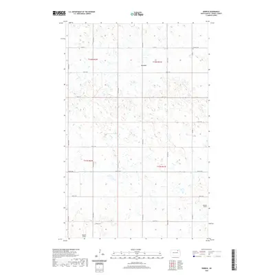
2020 Map of Derrick
USGS Topo · Published 2020About this map
Derrick sits at the heart of this Ramsey County landscape, appearing as a quiet crossroads settlement within a high-plains environment defined by numerous small depressions and seasonal wetlands. The agricultural character of the region is evident in the precise grid of section lines and gravel roads, including 73rd St NE and 97th Ave NE, which partition the prairie into large farming tracts. In the northeastern corner, Prospect Cem stands as a focal point for genealogical interest, located just off CO Hwy 4. The terrain is drained by the winding course of Edmore Coulee, which meanders through the southern and southeastern sections. This survey provides a clear view of the rural infrastructure of the early twenty-first century, showing the persistent settlement patterns and water management features of the North Dakota pothole region.
Find a feature on this map
21 named features on this map. Tap any name to fly to it.
Don’t see what you’re looking for? This feature index may not catch every label — zoom into the map to look around manually.
Map Details
Editions of this 2020 Derrick Map
This is the sole edition of this map. No revisions or reprints were ever made.
Other maps of this area

1953 · Devils Lake
USGS Topo · 1:250,000

1956 · Devils Lake
USGS Topo · 1:250,000

1970 · Alsen SE
USGS Topo · 1:24,000

1970 · Hampden
USGS Topo · 1:24,000

1972 · Derrick NW
USGS Topo · 1:24,000

1972 · Derrick
USGS Topo · 1:24,000

1972 · Derrick SE
USGS Topo · 1:24,000
1972 · Derrick SW
USGS Topo · 1:24,000

1972 · Edmore SW
USGS Topo · 1:24,000

1972 · Edmore
USGS Topo · 1:24,000