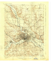
1954 Map of Des Moines
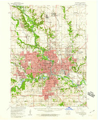
USGS Topo · Published 1973About this map
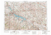
Des Moines serves as the focal point of this regional study, which documents the expansion of Central Iowa's infrastructure during the early 1970s. The landscape is defined by the massive water management projects of the Des Moines River valley, specifically the Saylorville Dam and Red Rock Dam, which created the expansive Saylorville Lake and Red Rock Reservoir. These engineering feats fundamentally altered the local topography, creating new recreation areas like Walnut Woods State Park while managing the river's flow through the heart of the state.
Find a feature on this map
119 named features on this map. Tap any name to fly to it.
Don’t see what you’re looking for? This feature index may not catch every label — zoom into the map to look around manually.
Map Details
Editions of this 1954 Des Moines Map
2 editions found

Historical Maps of Des Moines Through Time
8 maps found