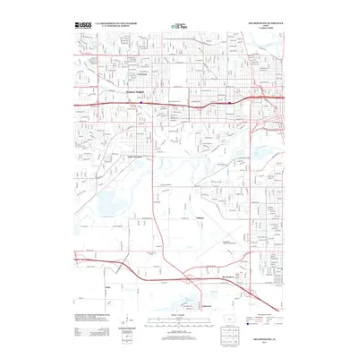
2013 Map of Des Moines SW
USGS Topo · Published 2013About this map
The Raccoon River and Walnut Creek converge in this western portion of the state capital, shaping a landscape defined by water and heavy infrastructure. The expansive footprint of the Des Moines International Airport dominates the southern reaches, while the historic rail-side identity of Valley Junction persists in the central corridor. Established residential neighborhoods like Windsor Heights and Crestwood sit north of the river, while the suburban southern edge transitions toward newer developments such as The Meadows and Lakewood. Extensive recreational and public spaces are evident throughout, from the Blank Park Zoo and Grays Lake in the east to the Willow Creek Golf Course and the wooded terrain along Browns Woods Drive. This era shows a dense network of major thoroughfares like Army Post Road and Grand Avenue connecting the disparate residential pockets and industrial zones.
Find a feature on this map
49 named features on this map. Tap any name to fly to it.
Don’t see what you’re looking for? This feature index may not catch every label — zoom into the map to look around manually.
Map Details
Editions of this 2013 Des Moines SW Map
This is the sole edition of this map. No revisions or reprints were ever made.
Other maps of this area

1905 · Des Moines
USGS Topo · 1:62,500

1907 · Des Moines
USGS Topo · 1:62,500

1908 · Waukee
USGS Topo · 1:62,500

1931 · Indianola
USGS Topo · 1:62,500

1951 · St. Charles
USGS Topo · 1:62,500

1954 · Des Moines
USGS Topo · 1:250,000

1956 · Des Moines
USGS Topo · 1:250,000

1956 · Des Moines NW
USGS Topo · 1:24,000

1956 · Des Moines SW
USGS Topo · 1:24,000

1956 · Des Moines SE
USGS Topo · 1:24,000