
1998 Map of Deseret Peak West
USGS Topo · Published 2001About this map
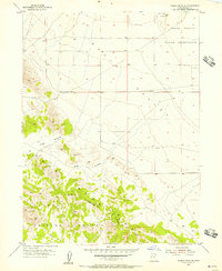
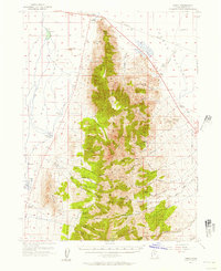
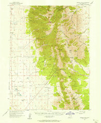
The Skull Valley Indian Reservation occupies the southwestern portion of this landscape, where the arid basin floor meets the steep western slopes of the Stansbury Mountains. Surveyed during the late 1990s, the map reveals a stark contrast between the open flats of Skull Valley and the high alpine terrain of the Wasatch National Forest. Within these heights, the Deseret Peak Wilderness protects the area surrounding Deseret Peak, the highest point on the sheet. Human infrastructure in this environment is sparse, centered primarily on water management as seen with the Aqueduct and various Wells dotting the valley floor. A small Cem (cemetery) is located near the reservation boundary, providing a point of interest for genealogists. The drainage system is defined by seasonal flows in Hickman Canyon, Indian Creek, and Big Creek, which flow westward toward the desert sink.
Find a feature on this map
26 named features on this map. Tap any name to fly to it.
Don’t see what you’re looking for? This feature index may not catch every label — zoom into the map to look around manually.
Map Details
Editions of this 1998 Deseret Peak West Map
This is the sole edition of this map. No revisions or reprints were ever made.
Other maps of this area

1885 · Tooele Valley
USGS Topo · 1:250,000

1953 · Tooele
USGS Topo · 1:250,000
1955 · Tabbys Peak SE
USGS Topo · 1:24,000
1955 · Timpie
USGS Topo · 1:62,500
1955 · Deseret Peak
USGS Topo · 1:62,500

1955 · Tooele
USGS Topo · 1:250,000

1973 · Hickman Knolls
USGS Topo · 1:24,000

1973 · Hastings Pass SE
USGS Topo · 1:24,000

1979 · Rush Valley
USGS Topo · 1:100,000

1979 · Tooele
USGS Topo · 1:100,000