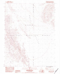
1983 Map of Desert Hills SE
USGS Topo · Published 1983About this map
The Desert National Wildlife Range dominates this corner of Lincoln County, where the transition between Mojave and Great Basin ecosystems is reflected in the dramatic relief of the Desert Hills. The 1983 topography reveals a landscape defined by restricted access and conservation, overlapping with the Nellis Air Force Range. This intersection of military and wildlife management is a hallmark of the Southern Nevada backcountry during the late Cold War era. High ridgelines of the Pahranagat Range and the Desert Range frame a broad Valley, showing the classic basin-and-range structure of the region. The map preserves the exact alignment of the Air Force Range Boundary, providing researchers with a record of federal land designations before subsequent modern expansions.
Find a feature on this map
7 named features on this map. Tap any name to fly to it.
Don’t see what you’re looking for? This feature index may not catch every label — zoom into the map to look around manually.
Map Details
Editions of this 1983 Desert Hills SE Map
This is the sole edition of this map. No revisions or reprints were ever made.
Other maps of this area

1907 · Las Vegas
USGS Topo · 1:250,000

1908 · Las Vegas
USGS Topo · 1:250,000

1945 · Sheep Range
USGS Topo · 1:125,000

1945 · Alamo
USGS Topo · 1:125,000

1954 · Caliente
USGS Topo · 1:250,000

1954 · Las Vegas
USGS Topo · 1:250,000

1957 · Las Vegas
USGS Topo · 1:250,000

1959 · Caliente
USGS Topo · 1:250,000

1959 · Las Vegas
USGS Topo · 1:250,000

1962 · Las Vegas
USGS Topo · 1:250,000