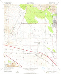
1955 Map of Desert Hot Springs
USGS Topo · Published 1961About this map
Desert Hot Springs occupies the northeastern edge of this mid-century survey, revealing the early layout of its residential streets at the base of the San Bernardino Mountains. The landscape transitions from the high peaks down into the Coachella Valley, where the Mission Creek Indian Reservation and the Southern Pacific railroad corridor define the local geography. Significant infrastructure of the era is evident, including a large Aqueduct and Pipe Line system designed to move water across this arid terrain. Remote outposts and family-held lands such as Lost Heads Ranch and Lazy C Ranch are documented alongside specialized sites like the Super Creek Mine and a high-elevation Airway Beacon on Whitewater Hill. The network of early desert roads, including Dillon Road and the Twentynine Palms Highway, connects these isolated settlements through the sandy washes and hills.
Find a feature on this map
26 named features on this map. Tap any name to fly to it.
Don’t see what you’re looking for? This feature index may not catch every label — zoom into the map to look around manually.
Map Details
Editions of this 1955 Desert Hot Springs Map
4 editions found
Other maps of this area

1901 · Southern California Sheet No. 1
USGS Topo · 1:250,000

1901 · San Jacinto
USGS Topo · 1:125,000

1902 · San Gorgonio
USGS Topo · 1:125,000

1904 · Southern California Sheet No. 1
USGS Topo · 1:250,000

1940 · Palm Springs
USGS Topo · 1:62,500

1941 · Edom
USGS Topo · 1:62,500

1944 · Palm Springs
USGS Topo · 1:62,500

1944 · Edom
USGS Topo · 1:62,500

1947 · Santa Ana
USGS Topo · 1:250,000

1949 · Santa Ana
USGS Topo · 1:250,000
Featured Places
- Cathedral City, CA
- Palm Springs, CA
- Desert Hot Springs, CA
- Dos Palmas Corners, CA
- North Palm Springs, CA