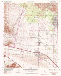
1955 Map of Desert Hot Springs
USGS Topo · Published 1987About this map
The Little San Bernardino Mountains frame the northern edge of this landscape, where the Colorado River Aqueduct cuts across the alluvial fans. This mid-century survey illustrates the early expansion of Desert Hot Springs, appearing here as a growing grid of streets against the desert floor. To the south, the infrastructure of the Southern Pacific railroad and the Twentynine Palms Highway converge near Garnet and the San Gorgonio Pass. The map captures a transitional era of desert development, documenting remote outposts like Lost Heads Ranch and the industrial presence of the Super Creek Mine. Water management is central to the area's geography, with the Whitewater River and numerous washes such as Big Morongo Creek and Mission Creek carving paths through the arid terrain toward North Palm Springs.
Find a feature on this map
39 named features on this map. Tap any name to fly to it.
Don’t see what you’re looking for? This feature index may not catch every label — zoom into the map to look around manually.
Map Details
Editions of this 1955 Desert Hot Springs Map
4 editions found
Other maps of this area

1901 · Southern California Sheet No. 1
USGS Topo · 1:250,000

1901 · San Jacinto
USGS Topo · 1:125,000

1902 · San Gorgonio
USGS Topo · 1:125,000

1904 · Southern California Sheet No. 1
USGS Topo · 1:250,000

1940 · Palm Springs
USGS Topo · 1:62,500

1941 · Edom
USGS Topo · 1:62,500

1944 · Palm Springs
USGS Topo · 1:62,500

1944 · Edom
USGS Topo · 1:62,500

1947 · Santa Ana
USGS Topo · 1:250,000

1949 · Santa Ana
USGS Topo · 1:250,000
Featured Places
- Cathedral City, CA
- Palm Springs, CA
- Desert Hot Springs, CA
- Dos Palmas Corners, CA
- North Palm Springs, CA