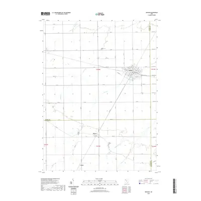
2019 Map of Deshler
USGS Topo · Published 2019About this map
The village of Deshler serves as the primary hub of this Northwest Ohio landscape, where a dense network of local streets like W Main St and E Maple St gives way to the rectilinear agricultural plots of Henry and Putnam counties. The landscape is defined by the slow drainage of several waterways, including Hammer Cr and Beaver Cr, which meander through the flat plains. Further south, the settlements of Belmore and the northern edge of Leipsic appear along the rail-influenced corridors, maintaining their distinct footprints in an area dominated by large-scale farming. Genealogical value is found in the distribution of community burial sites, from Woodlawn Cem north of the main village to the West Belmore Cem and East Belmore Cem, which flank the crossroads at Belmore, anchoring the history of the families that settled these townships.
Find a feature on this map
65 named features on this map. Tap any name to fly to it.
Don’t see what you’re looking for? This feature index may not catch every label — zoom into the map to look around manually.
Map Details
Editions of this 2019 Deshler Map
This is the sole edition of this map. No revisions or reprints were ever made.
Other maps of this area

1908 · Ottawa
USGS Topo · 1:62,500

1908 · Napoleon
USGS Topo · 1:62,500

1909 · Mc Clure
USGS Topo · 1:62,500

1953 · Fort Wayne
USGS Topo · 1:250,000

1956 · Fort Wayne
USGS Topo · 1:250,000

1956 · Toledo
USGS Topo · 1:250,000

1960 · Deshler
USGS Topo · 1:24,000

1960 · Ottawa
USGS Topo · 1:24,000
1960 · Hamler
USGS Topo · 1:24,000
1960 · Malinta
USGS Topo · 1:24,000