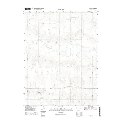
2014 Map of Deshler
USGS Topo · Published 2014About this map
Deshler occupies the southwestern corner of this survey, established as a central point of activity along the Us-136 corridor in Thayer County. The landscape is defined by the winding course of the Little Blue River, which meanders across the northern half of the quadrangle, flanked by numerous small drainage patterns and agricultural section roads. To the north, the S Fork Big Sandy Cr cuts through the plains, while Spring Creek feeds into the local hydrology near the town site. For genealogical researchers, the map identifies specific local burial grounds including Peace Cem and Saint Peters Cem, located just north of the primary settlement. The eastern portion of the map is notable for the Wiedel Reservoir, a significant water feature in an otherwise strictly surveyed grid of rural road networks such as Road QR and Road 5800.
Find a feature on this map
26 named features on this map. Tap any name to fly to it.
Don’t see what you’re looking for? This feature index may not catch every label — zoom into the map to look around manually.
Map Details
Editions of this 2014 Deshler Map
This is the sole edition of this map. No revisions or reprints were ever made.
Other maps of this area

1898 · Hebron
USGS Topo · 1:125,000

1955 · Lincoln
USGS Topo · 1:250,000

1957 · Lincoln
USGS Topo · 1:250,000

1958 · Lincoln
USGS Topo · 1:250,000

1960 · Bruning
USGS Topo · 1:24,000

1960 · Byron
USGS Topo · 1:24,000

1960 · Davenport
USGS Topo · 1:24,000

1960 · Chester
USGS Topo · 1:24,000

1960 · Carleton
USGS Topo · 1:24,000
1960 · Ruskin
USGS Topo · 1:24,000