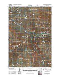
2011 Map of Desolation Butte
USGS Topo · Published 2011About this map
Desolation Butte and the surrounding high country of Grant County are defined by a network of drainage basins and high-elevation outposts. This landscape is a patchwork of namesake camps such as Sponge Creek Camp, Lower Howard Camp, and Jumpoff Joe Camp, which suggest a history of seasonal resource management and forestry. The topography is anchored by prominent summits including Jumpoff Joe Peak and Indian Rock, both of which serve as strategic vantage points marked by the Desolation Butte Lookout and Indian Rock Lookout.
Find a feature on this map
38 named features on this map. Tap any name to fly to it.
Don’t see what you’re looking for? This feature index may not catch every label — zoom into the map to look around manually.
Map Details
Editions of this 2011 Desolation Butte Map
This is the sole edition of this map. No revisions or reprints were ever made.
Other maps of this area

1949 · Susanville
USGS Topo · 1:62,500

1951 · Susanville
USGS Topo · 1:62,500

1951 · Dale
USGS Topo · 1:62,500

1951 · Bates
USGS Topo · 1:62,500

1951 · Desolation Butte
USGS Topo · 1:62,500

1955 · Canyon City
USGS Topo · 1:250,000

1959 · Canyon City
USGS Topo · 1:250,000
1987 · Bates
USGS Topo · 1:100,000
1988 · Vinegar Hill
USGS Topo · 1:24,000
1988 · Desolation Butte
USGS Topo · 1:24,000