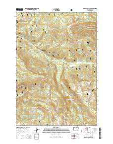
2014 Map of Desolation Butte
USGS Topo · Published 2014About this map
Desolation Butte stands at the heart of this high-elevation landscape in eastern Oregon, marking a boundary zone within the Umatilla National Forest. The map documents a complex drainage system where the N Fork Desolation Cr and S Fork Desolation Cr converge near Desolation Meadows. This area is characterized by significant topographic relief, from the heights of Jumpoff Joe Peak and the Greenhorn Mountains to the secluded waters of Jumpoff Joe Lake and Lost Lake. To the south, the terrain transitions into the Malhuer National Forest near Indian Rock and Squaw Rock. The presence of numerous springs like Cold Spring and Sunset Spring highlights the crucial water sources that sustain this wilderness area, while Sharp Ridge defines the western reaches of the quadrangle.
Find a feature on this map
39 named features on this map. Tap any name to fly to it.
Don’t see what you’re looking for? This feature index may not catch every label — zoom into the map to look around manually.
Map Details
Editions of this 2014 Desolation Butte Map
This is the sole edition of this map. No revisions or reprints were ever made.
Other maps of this area

1949 · Susanville
USGS Topo · 1:62,500

1951 · Susanville
USGS Topo · 1:62,500

1951 · Dale
USGS Topo · 1:62,500

1951 · Bates
USGS Topo · 1:62,500

1951 · Desolation Butte
USGS Topo · 1:62,500

1955 · Canyon City
USGS Topo · 1:250,000

1959 · Canyon City
USGS Topo · 1:250,000
1987 · Bates
USGS Topo · 1:100,000
1988 · Vinegar Hill
USGS Topo · 1:24,000
1988 · Desolation Butte
USGS Topo · 1:24,000