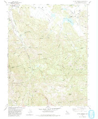
1993 Map of Detert Reservoir
USGS Topo · Published 1993About this map
The rugged boundary between Lake, Napa, and Sonoma counties is dominated by the mercury and silver mining legacy of the Mayacmas Mountains. This 1993 revision reveals a landscape defined by historic extraction, featuring numerous workings such as the Oat Hill Mine, Silverado Mine, and Mirabel Mine. The southern portion of the map is largely occupied by Robert Louis Stevenson State Park, preserving the high elevations of the range including The Palisades and Table Rock. To the north, the terrain transitions into the ranch lands of Guenoc and the Collayomi Rancho, where the Detert Reservoir and several landing strips service the local area near Middletown. The intricate network of creeks, such as St Helena Creek and Bucksnort Creek, illustrates the complex drainage patterns feeding into the larger valleys below these volcanic peaks.
Find a feature on this map
74 named features on this map. Tap any name to fly to it.
Don’t see what you’re looking for? This feature index may not catch every label — zoom into the map to look around manually.
Map Details
Editions of this 1993 Detert Reservoir Map
This is the sole edition of this map. No revisions or reprints were ever made.
Other maps of this area

1927 · Calistoga
USGS Topo · 1:62,500

1942 · St. Helena
USGS Topo · 1:62,500

1943 · Morgan Valley
USGS Topo · 1:62,500

1943 · Calistoga
USGS Topo · 1:62,500

1944 · Morgan Valley
USGS Topo · 1:62,500

1945 · Calistoga
USGS Topo · 1:62,500

1945 · St. Helena
USGS Topo · 1:62,500

1945 · Lower Lake
USGS Topo · 1:62,500

1947 · Santa Rosa
USGS Topo · 1:250,000

1949 · Santa Rosa
USGS Topo · 1:250,000