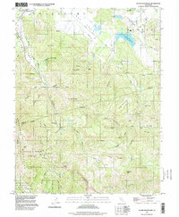
1997 Map of Detert Reservoir
USGS Topo · Published 1998About this map
Collayomi Valley anchors the northern reaches of this landscape, where the settlement of Middletown sits near the base of St Helena Creek. The topography is defined by significant quicksilver mining history, evidenced by a high density of named workings including the Oat Hill Mine, Mirabel Mine, and Silverado Mine scattered across the ridges. The eastern portion is dominated by the Detert Reservoir and the drainage of Bucksnort Creek, while the southern boundary includes the dramatic verticality of The Palisades and the protected lands of Robert Louis Stevenson State Park. This terrain reflects the complex geology of the Mayacamas Mountains at the intersection of Lake, Napa, and Sonoma counties, showcasing the transition from valley floor agriculture to high-altitude mineral extraction sites like the Corona Mine and Magnolia Mine.
Find a feature on this map
62 named features on this map. Tap any name to fly to it.
Don’t see what you’re looking for? This feature index may not catch every label — zoom into the map to look around manually.
Map Details
Editions of this 1997 Detert Reservoir Map
This is the sole edition of this map. No revisions or reprints were ever made.
Other maps of this area

1927 · Calistoga
USGS Topo · 1:62,500

1942 · St. Helena
USGS Topo · 1:62,500

1943 · Morgan Valley
USGS Topo · 1:62,500

1943 · Calistoga
USGS Topo · 1:62,500

1944 · Morgan Valley
USGS Topo · 1:62,500

1945 · Calistoga
USGS Topo · 1:62,500

1945 · St. Helena
USGS Topo · 1:62,500

1945 · Lower Lake
USGS Topo · 1:62,500

1947 · Santa Rosa
USGS Topo · 1:250,000

1949 · Santa Rosa
USGS Topo · 1:250,000