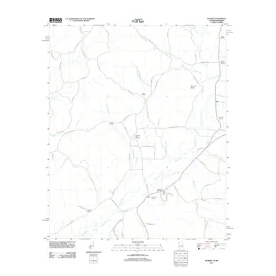
2011 Map of Detroit
USGS Topo · Published 2011About this map
Sipsey Creek and its many tributaries, including Bluegut Creek and Little Dry Creek, define the landscape of this border region where Alabama meets Mississippi. The town of Detroit serves as a local hub, anchored by the Detroit Post Office and surrounded by the West Detroit Gas Field. This 2011 survey reveals a territory marked by deep ancestral roots, evidenced by numerous family burial grounds scattered across the countryside. From the Rudicell Cemetery in the northeast to the Carter Cemetery near the town center, these sites provide significant touchstones for genealogical research. The presence of Dinky Line Rd suggests historical industrial or light rail activity, while the settlement of Byrd remains a distinct point on the map near Factory Creek. The road network, including State Line Rd SE, follows the natural contours of the drainage basins, illustrating the enduring relationship between the topography and local transport.
Find a feature on this map
72 named features on this map. Tap any name to fly to it.
Don’t see what you’re looking for? This feature index may not catch every label — zoom into the map to look around manually.
Map Details
Editions of this 2011 Detroit Map
This is the sole edition of this map. No revisions or reprints were ever made.
Other maps of this area

1953 · West Point
USGS Topo · 1:250,000

1956 · Tupelo
USGS Topo · 1:250,000

1958 · Tupelo
USGS Topo · 1:250,000

1958 · West Point
USGS Topo · 1:250,000

1963 · West Point
USGS Topo · 1:250,000

1966 · Turon
USGS Topo · 1:24,000

1966 · Tremont
USGS Topo · 1:24,000

1966 · Greenwood Springs
USGS Topo · 1:24,000

1967 · Sulligent
USGS Topo · 1:24,000
1967 · Weston
USGS Topo · 1:24,000