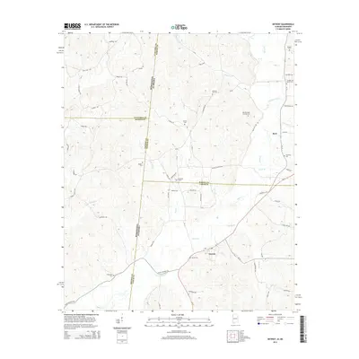
2014 Map of Detroit
USGS Topo · Published 2014About this map
The Mississippi Alabama border divides this 2014 survey, capturing the rural landscape where Lamar Co and Marion Co meet the state line. At the center of the regional road network lies the settlement of Detroit, situated near the confluence of Reedy Br and Sipsey Cr. The map reveals a deeply rooted community landscape defined by family-named landmarks and historical cemeteries, including Carter Cem, Riggans Cem, and the Holligan and Moore Cem. To the north, the small community of Byrd sits along Al-19, surrounded by small waterways such as Factory Cr and Aston Br. The presence of Dinky Line Rd south of Byrd suggests the legacy of historical timber or industrial transport routes that once carved through the woodland. Numerous creeks like Bluegut Cr and Northington Br drain the undulating terrain, which is crisscrossed by an extensive network of local routes like State Line Rd and Co Highway 26.
Find a feature on this map
75 named features on this map. Tap any name to fly to it.
Don’t see what you’re looking for? This feature index may not catch every label — zoom into the map to look around manually.
Map Details
Editions of this 2014 Detroit Map
This is the sole edition of this map. No revisions or reprints were ever made.
Other maps of this area

1953 · West Point
USGS Topo · 1:250,000

1956 · Tupelo
USGS Topo · 1:250,000

1958 · Tupelo
USGS Topo · 1:250,000

1958 · West Point
USGS Topo · 1:250,000

1963 · West Point
USGS Topo · 1:250,000

1966 · Turon
USGS Topo · 1:24,000

1966 · Tremont
USGS Topo · 1:24,000

1966 · Greenwood Springs
USGS Topo · 1:24,000

1967 · Sulligent
USGS Topo · 1:24,000
1967 · Weston
USGS Topo · 1:24,000