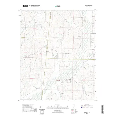
2020 Map of Detroit
USGS Topo · Published 2020About this map
Detroit anchors the lower-central portion of this landscape, situated near the intersection of the Marion Co Lamar Co boundary. The area is defined by a dense network of watercourses, including Bluegut Cr, Dry Cr, and the southward-flowing Sipsey Cr, which drain the undulating terrain of the Alabama-Mississippi borderlands. The border itself is clearly delineated, marking the transition between Mississippi and Alabama across several townships and ranges.
Find a feature on this map
86 named features on this map. Tap any name to fly to it.
Don’t see what you’re looking for? This feature index may not catch every label — zoom into the map to look around manually.
Map Details
Editions of this 2020 Detroit Map
This is the sole edition of this map. No revisions or reprints were ever made.
Other maps of this area

1953 · West Point
USGS Topo · 1:250,000

1956 · Tupelo
USGS Topo · 1:250,000

1958 · Tupelo
USGS Topo · 1:250,000

1958 · West Point
USGS Topo · 1:250,000

1963 · West Point
USGS Topo · 1:250,000

1966 · Turon
USGS Topo · 1:24,000

1966 · Tremont
USGS Topo · 1:24,000

1966 · Greenwood Springs
USGS Topo · 1:24,000

1967 · Sulligent
USGS Topo · 1:24,000
1967 · Weston
USGS Topo · 1:24,000