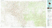
1985 Map of Devils Draw
USGS Topo · Published 1994About this map
The Pecos River carves a deep path through this landscape, serving as a vital artery in the semi-arid terrain of the Edwards Plateau. The settlement of Pandale is a focal point for the region, positioned near the river's crossing in an area defined by massive drainage systems like Howard Draw and Big Fielder Draw. To the east, the headwaters of the Devils River begin to emerge, while the remote Terrell Station marks the western reach near the Terrell and Crockett county lines. The map reveals an intricate network of deep canyons, including Richland Canyon and Oppenheimer Canyon, which dictate the movement of roads and sparse settlements. This 1985 compilation highlights the enduring land-use patterns of West Texas, where ranching and water access define the human footprint among the draws.
Find a feature on this map
27 named features on this map. Tap any name to fly to it.
Don’t see what you’re looking for? This feature index may not catch every label — zoom into the map to look around manually.
Map Details
Editions of this 1985 Devils Draw Map
2 editions found
Other maps of this area

1918 · Dryden Crossing
USGS Topo · 1:62,500

1928 · Sanderson
USGS Topo · 1:125,000

1929 · Sheffield
USGS Topo · 1:125,000

1929 · Independence Draw Quadrangle
USGS Topo · 1:125,000

1943 · Malvado
USGS Topo · 1:62,500

1943 · Langtry
USGS Topo · 1:62,500

1943 · Shumla
USGS Topo · 1:62,500

1944 · Dry Devil
USGS Topo · 1:62,500

1944 · Malvado
USGS Topo · 1:62,500

1944 · Baker Crossing
USGS Topo · 1:62,500