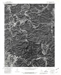
1976 Map of Devils Elbow
USGS Topo · Published 1980About this map
The winding course of the Big Piney River and the Gasconade River dominates this Ozark landscape in the mid-1970s. This orthophotoquad captures the physical reality of the terrain as it appeared during the bicentennial era, showcasing the sharp meander at Devils Elbow and the dense woodland surrounding local settlements. The southern portion of the sheet is marked by the expansive footprint of Fort Leonard Wood, where established infrastructure contrasts with the narrow valley roads and forested ridges of the Missouri interior. Small residential clusters like Morgan Heights and Hooker sit along the primary transit corridors, while the junction of the Big Piney and Spring Creek illustrates the intricate drainage patterns of Pulaski County. This aerial perspective, combined with land lines from a previous 1954 topographic survey, reveals the extent of post-war development in a region shaped by both military presence and rugged geography.
Find a feature on this map
8 named features on this map. Tap any name to fly to it.
Don’t see what you’re looking for? This feature index may not catch every label — zoom into the map to look around manually.
Map Details
Editions of this 1976 Devils Elbow Map
This is the sole edition of this map. No revisions or reprints were ever made.
Other maps of this area

1912 · Rolla
USGS Topo · 1:62,500

1936 · Waynesville
USGS Topo · 1:48,000

1937 · Edgar Springs
USGS Topo · 1:48,000

1941 · Big Piney
USGS Topo · 1:62,500

1942 · Waynesville
USGS Topo · 1:62,500

1943 · Big Piney
USGS Topo · 1:62,500

1944 · Waynesville
USGS Topo · 1:62,500

1945 · Edgar Springs
USGS Topo · 1:62,500

1949 · Rolla
USGS Topo · 1:250,000

1950 · Newburg
USGS Topo · 1:24,000