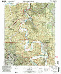
2004 Map of Devils Elbow
USGS Topo · Published 2006About this map
Devils Elbow sits at a sharp bend in the Big Piney River, marking a transition from the river's winding course to the high ridges of the Mark Twain National Forest. The landscape is defined by the heavy presence of the Fort Leonard Wood Military Reservation to the south and west, where the Fort Wood Lookout stands over a network of service roads and ranges. This 2004 revision reveals a mix of old Ozark settlements and modern development, with clusters of Mobile Home Park sites near St Robert contrasting against isolated historic sites. Genealogists will find several burial grounds across the terrain, including Spaulding Cem near the Gasconade River and the remote Hale Cem. The rail influence is preserved through names like Wern Siding and Lee Siding along the northern corridor, while the Moab (Site) on the riverbank serves as a marker of a location no longer actively settled.
Find a feature on this map
38 named features on this map. Tap any name to fly to it.
Don’t see what you’re looking for? This feature index may not catch every label — zoom into the map to look around manually.
Map Details
Editions of this 2004 Devils Elbow Map
This is the sole edition of this map. No revisions or reprints were ever made.
Other maps of this area

1912 · Rolla
USGS Topo · 1:62,500

1936 · Waynesville
USGS Topo · 1:48,000

1937 · Edgar Springs
USGS Topo · 1:48,000

1941 · Big Piney
USGS Topo · 1:62,500

1942 · Waynesville
USGS Topo · 1:62,500

1943 · Big Piney
USGS Topo · 1:62,500

1944 · Waynesville
USGS Topo · 1:62,500

1945 · Edgar Springs
USGS Topo · 1:62,500

1949 · Rolla
USGS Topo · 1:250,000

1950 · Newburg
USGS Topo · 1:24,000